Humber 2100+
Humber 2100+ is a partnership working on a new long-term strategy to manage tidal flood risk in the Humber region over the next 100 years.
There are over half a million people and thousands of businesses within the Humber 2100+ study area, as well as thousands of hectares of land, important industry, and infrastructure. It is also an internationally important natural asset for both people and wildlife. However, a substantial portion of this region is at risk of flooding during an extreme flood event.
As sea level rise accelerates, severe flooding will happen much more often, and we need to rethink how we manage the impacts so communities can continue to thrive.
To find out more about the background of this work, and why it's so important, explore the information bar or click here. Remember to check for the Latest News updates at the bottom of the page, and opportunities to get involved!
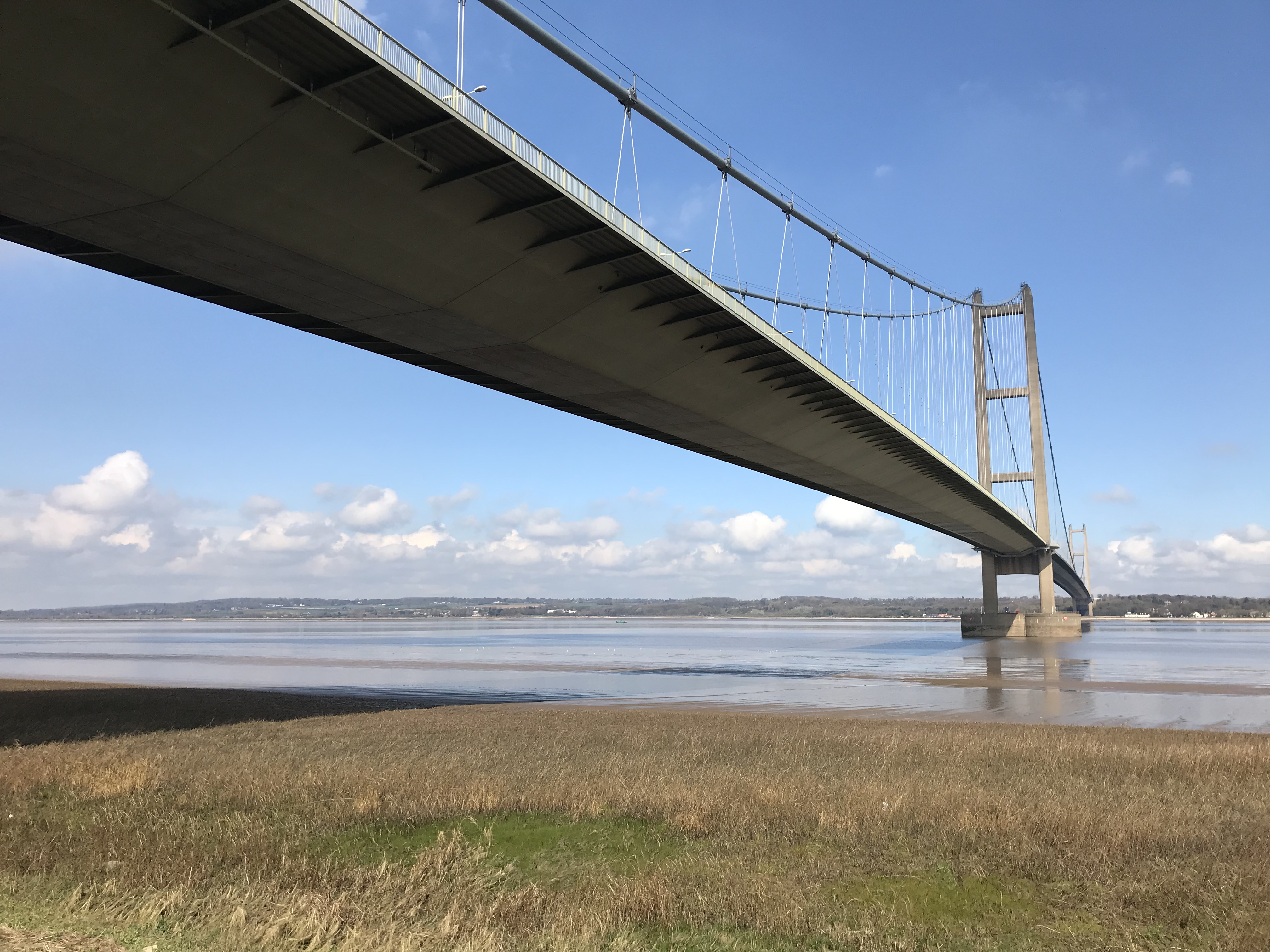
View of the Humber Bridge from the south bank
Get involved now!
Local people, businesses and other interested parties will be able to participate in the development of the new Humber Strategy. We will engage and consult at key decision points and encourage you to get involved and help us shape the future of the Humber Estuary. We want to know more about you, the people, communities and organisations that this strategy will reach.
We want you to Register and Subscribe, so we can notify you of the latest news and updates for Humber 2100+.
If you've already got ideas you want to share with us, use the "tell us what you think" tool below. Or, if you have a question, use the "ask a question" tab below. We want to grow a community around the Humber 2100+ strategy and would love to share your ideas and questions with everyone else, but we will always ask you first.
Check your flood risk and prepare
Climate change is one of the biggest global threats we face. Globally, intense storms are becoming more frequent and climate change is already increasing sea levels around the UK coast. Although we work tirelessly to reduce the risk of flooding, we can never eliminate the risk completely.
With large areas around the Humber at risk of tidal flooding, it is important for us to work together to ensure that communities and businesses are better prepared for flooding.
In order for the Humber to thrive and continue to be a great place to live and work, the partnership is committed to working with others and the wider community to help lessen the impact that flooding can have on homes, land and businesses on and around the estuary.
What you can do to be better prepared:
- Check your flood risk
- Sign up for Free Flood Warnings
- Prepare a personal or business flood plan
- Install property level resilience

Humber 2100+ is a partnership working on a new long-term strategy to manage tidal flood risk in the Humber region over the next 100 years.
There are over half a million people and thousands of businesses within the Humber 2100+ study area, as well as thousands of hectares of land, important industry, and infrastructure. It is also an internationally important natural asset for both people and wildlife. However, a substantial portion of this region is at risk of flooding during an extreme flood event.
As sea level rise accelerates, severe flooding will happen much more often, and we need to rethink how we manage the impacts so communities can continue to thrive.
To find out more about the background of this work, and why it's so important, explore the information bar or click here. Remember to check for the Latest News updates at the bottom of the page, and opportunities to get involved!
View of the Humber Bridge from the south bank
Get involved now!
Local people, businesses and other interested parties will be able to participate in the development of the new Humber Strategy. We will engage and consult at key decision points and encourage you to get involved and help us shape the future of the Humber Estuary. We want to know more about you, the people, communities and organisations that this strategy will reach.
We want you to Register and Subscribe, so we can notify you of the latest news and updates for Humber 2100+.
If you've already got ideas you want to share with us, use the "tell us what you think" tool below. Or, if you have a question, use the "ask a question" tab below. We want to grow a community around the Humber 2100+ strategy and would love to share your ideas and questions with everyone else, but we will always ask you first.
Check your flood risk and prepare
Climate change is one of the biggest global threats we face. Globally, intense storms are becoming more frequent and climate change is already increasing sea levels around the UK coast. Although we work tirelessly to reduce the risk of flooding, we can never eliminate the risk completely.
With large areas around the Humber at risk of tidal flooding, it is important for us to work together to ensure that communities and businesses are better prepared for flooding.
In order for the Humber to thrive and continue to be a great place to live and work, the partnership is committed to working with others and the wider community to help lessen the impact that flooding can have on homes, land and businesses on and around the estuary.
What you can do to be better prepared:
- Check your flood risk
- Sign up for Free Flood Warnings
- Prepare a personal or business flood plan
- Install property level resilience

-
Key milestone reached for Humber 2100+
The Humber 2100+ ’Understand Risk’ evidence base has now been endorsed by all members of the partnership. This is a key milestone for the project as these outputs form the basis for understanding strategic flood risk across the Humber going forwards and enable us to work together on an adaptive approach to managing tidal risk across the interconnected estuary system.
The outputs from Understand Risk will inform the next stages of the project, as well as shaping our ongoing investment on the ground. The project team and partners are currently focused on moving into ‘Agree approaches’ (Step 2), with aContinue reading
The Humber 2100+ ’Understand Risk’ evidence base has now been endorsed by all members of the partnership. This is a key milestone for the project as these outputs form the basis for understanding strategic flood risk across the Humber going forwards and enable us to work together on an adaptive approach to managing tidal risk across the interconnected estuary system.
The outputs from Understand Risk will inform the next stages of the project, as well as shaping our ongoing investment on the ground. The project team and partners are currently focused on moving into ‘Agree approaches’ (Step 2), with a number of key areas of work progressing. These include reviewing our governance arrangements to ensure they are still appropriate as we move into the next stage of the project; consideration of the evidence required to produce ‘approaches’ for managing tidal flood risk; and reflections on the lessons learned from Understand Risk. The partnership is also working on ways to present the Understand Risk outputs to the wider public.

-
Outstrays to Skeffling Managed Realignment (OtSMRS) - Widening the breach
The site continues to attract visitors, and formal opening events are being planned for later in the year, by which time the interpretation and welcome boards are planned to be in place.
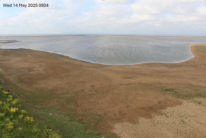
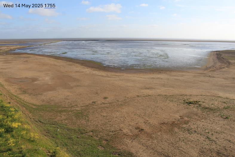
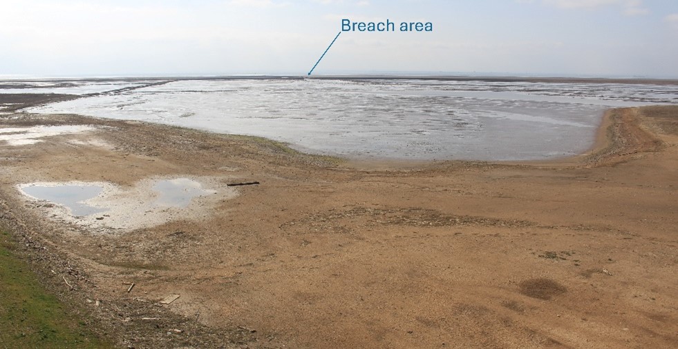
Following the expected breach erosion over the winter, work began in April on additional work to widen the breach area to enable the tidal water to leave the site more quickly between tides. This has made a significant improvement to the reduction of water on the site. This can be seen in the pictures below taken on 14th May, we will continue to monitor progress.
Skeffling and WinesteadContinue reading
The site continues to attract visitors, and formal opening events are being planned for later in the year, by which time the interpretation and welcome boards are planned to be in place.
Following the expected breach erosion over the winter, work began in April on additional work to widen the breach area to enable the tidal water to leave the site more quickly between tides. This has made a significant improvement to the reduction of water on the site. This can be seen in the pictures below taken on 14th May, we will continue to monitor progress.
Skeffling and Winestead pumping station works are both continuing to progress well with the recent good weather we have had. Skeffling pumping station is expected to be complete by the end of this winter.
08:04 showing higher water levels
17:55 showing reduced water levels -
Middle Humber - Capital Maintenance Programme (MH-CaMP) - Work to secure approvals continues
We continue to progress the development of the project to enable investment in maintaining our flood risk management assets in the Middle Humber area. The initial bundle will be delivered in 3 work packages, one on the left-bank of the Dutch River upstream of Goole and then one either side of the River Ouse at Reedness and Yokefleet. We are working on the business case and the approvals needed to proceed and this is expected to take until next summer to complete. Once the first package is underway, we will start work to secure the approvals for the second packageContinue reading
We continue to progress the development of the project to enable investment in maintaining our flood risk management assets in the Middle Humber area. The initial bundle will be delivered in 3 work packages, one on the left-bank of the Dutch River upstream of Goole and then one either side of the River Ouse at Reedness and Yokefleet. We are working on the business case and the approvals needed to proceed and this is expected to take until next summer to complete. Once the first package is underway, we will start work to secure the approvals for the second package of works

-
Beckingham Marshes - background investigations towards developing a business case continue
Progress on this project has been impacted by ongoing recovery works. However, we continue to develop investigations and development of a business case which is aimed at repairing a dewatering structure that is coming to the end of its life and compliance with the reservoir act. Investigation works and analysis are ongoing and supporting the funding allocation by outlining costs for the SSBC. The project team have secured moderation funding to support the project up to SSBC submission, further moderation funding is pending approval for next year and beyond.
-
Barton to New Holland Tidal Flood Alleviation Scheme - exploring funding opportunities and planning ahead
Click here to find out more about the Barton Scheme
The Outline Business Case (OBC) was submitted by late May. However, there is still a substantial funding gap based on current estimates. The project team have a plan to reduce costs whilst trying to explore additional funding opportunities. Support from North Lincolnshire Council has been obtained through their Strategic Water Management Board.

Following OBC approval the project team will be focussed on detailed design, consents and approvals. They will also continue with necessary ecology surveys and second phase of ground investigation. Construction is now expected over a number of yearsContinue reading
Click here to find out more about the Barton Scheme
The Outline Business Case (OBC) was submitted by late May. However, there is still a substantial funding gap based on current estimates. The project team have a plan to reduce costs whilst trying to explore additional funding opportunities. Support from North Lincolnshire Council has been obtained through their Strategic Water Management Board.

Following OBC approval the project team will be focussed on detailed design, consents and approvals. They will also continue with necessary ecology surveys and second phase of ground investigation. Construction is now expected over a number of years. However, embankment repairs at Barrow Haven may be able to be undertaken beforehand, after necessary investigations and surveys over the next year.
The project’s Resilience Advisory Group continue to be informed of progress, and further guidance will be sought from the Steering Group regarding the quantified funding gap. North Lincolnshire Council have been approached to make a funding contribution to aid this situation.
-
Birthday Buoy! Celebrating one year of the Spurn wave buoy deployment
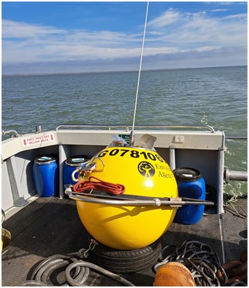
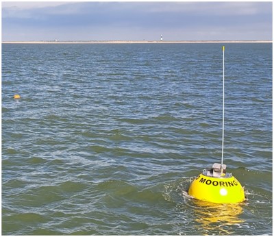
June 2025 marks the first anniversary of the wave buoy deployed 3km southeast of Spurn Point, as part of the Humber Strategic Monitoring Programme.
The buoy fills a crucial gap in the North Sea’s monitoring network, positioned between the Hornsea buoy to the north and the Chapel Point buoy to the south. We’ve worked closely with the National Network of Regional Coastal Monitoring Programmes and their contractors, as well as the National Oceanography Centre, and the Humber Harbour Authority, ABP, to develop and deliver this project.
Over the past year, the buoy has been hard at work, collecting vital dataContinue readingJune 2025 marks the first anniversary of the wave buoy deployed 3km southeast of Spurn Point, as part of the Humber Strategic Monitoring Programme.
The buoy fills a crucial gap in the North Sea’s monitoring network, positioned between the Hornsea buoy to the north and the Chapel Point buoy to the south. We’ve worked closely with the National Network of Regional Coastal Monitoring Programmes and their contractors, as well as the National Oceanography Centre, and the Humber Harbour Authority, ABP, to develop and deliver this project.
Over the past year, the buoy has been hard at work, collecting vital data on:
🌊 Wave height, length and direction
🌡️ Sea surface temperature
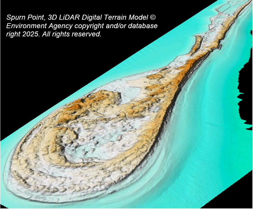
This data helps us identify short-term variations in the sea state, and longer-term trends in the wave climate at the mouth of the estuary, providing insights we can integrate into technical assessments and monitoring.Importantly, this data will help us better understand the critical role played by Spurn Point – the iconic sand and shingle spit that stretches south from the Holderness coast into the Humber – in shielding the estuary from the full brunt of North Sea waves.

🔗 Want to dive deeper? Check out the links below to find out more about the monitoring programme, Spurn Point, and how the landscape has changed over time.
- National Network of Regional Coastal Monitoring Programmes - Spurn Point
- WaveNet – Details
- Understanding historical coastal spit evolution: A case study from Spurn, East Yorkshire, UK Earth Surface Processes and Landforms | Geomorphology Journal | Wiley Online Library
- More on Yorkshire Wildlife Trust’s National Nature Reserve at Spurn Spurn | YWT
- “The Myth of Spurn” The imagined formation of the magical landscape of Spurn Zines | Janerobb


Images courtesy of Fugro 2024 -
Stallingborough Phase 3 Sea Defence Improvements - revetment works near completion
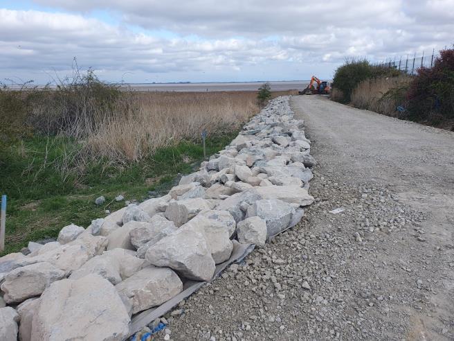
The 3rd year of construction activities commenced early in March, with consent from Natural England. The four small rock amour in-fill areas are due to be installed later this summer. This will complete the defence revetment works.
The access track to the outfall of New Cut Drain has been completed, and the design to cross over the Anglian Water main sewers has been approved. The installation is expected to be completed by the Autumn. At Oldfleet Drain the design of the overflow has been developed collaboratively with key stakeholders and the construction of the access track to the outfall isContinue reading
The 3rd year of construction activities commenced early in March, with consent from Natural England. The four small rock amour in-fill areas are due to be installed later this summer. This will complete the defence revetment works.
The access track to the outfall of New Cut Drain has been completed, and the design to cross over the Anglian Water main sewers has been approved. The installation is expected to be completed by the Autumn. At Oldfleet Drain the design of the overflow has been developed collaboratively with key stakeholders and the construction of the access track to the outfall is underway. The MMO have given the required consents for the desilting work to start using a dredging barge.
New Cut Drain Outfall access trackThe funding contribution from National Highways has been received and this should enable additional resilience works to the outfalls to be undertaken within the project. The project will be able to ensure no net loss to biodiversity through the planting of an enhanced seed mix along some of the landward berm. The project team also continue to explore the possibility of further environmental enhancement of the adjacent saltmarsh.
-
Strategy Update - Understanding Risk around the Humber
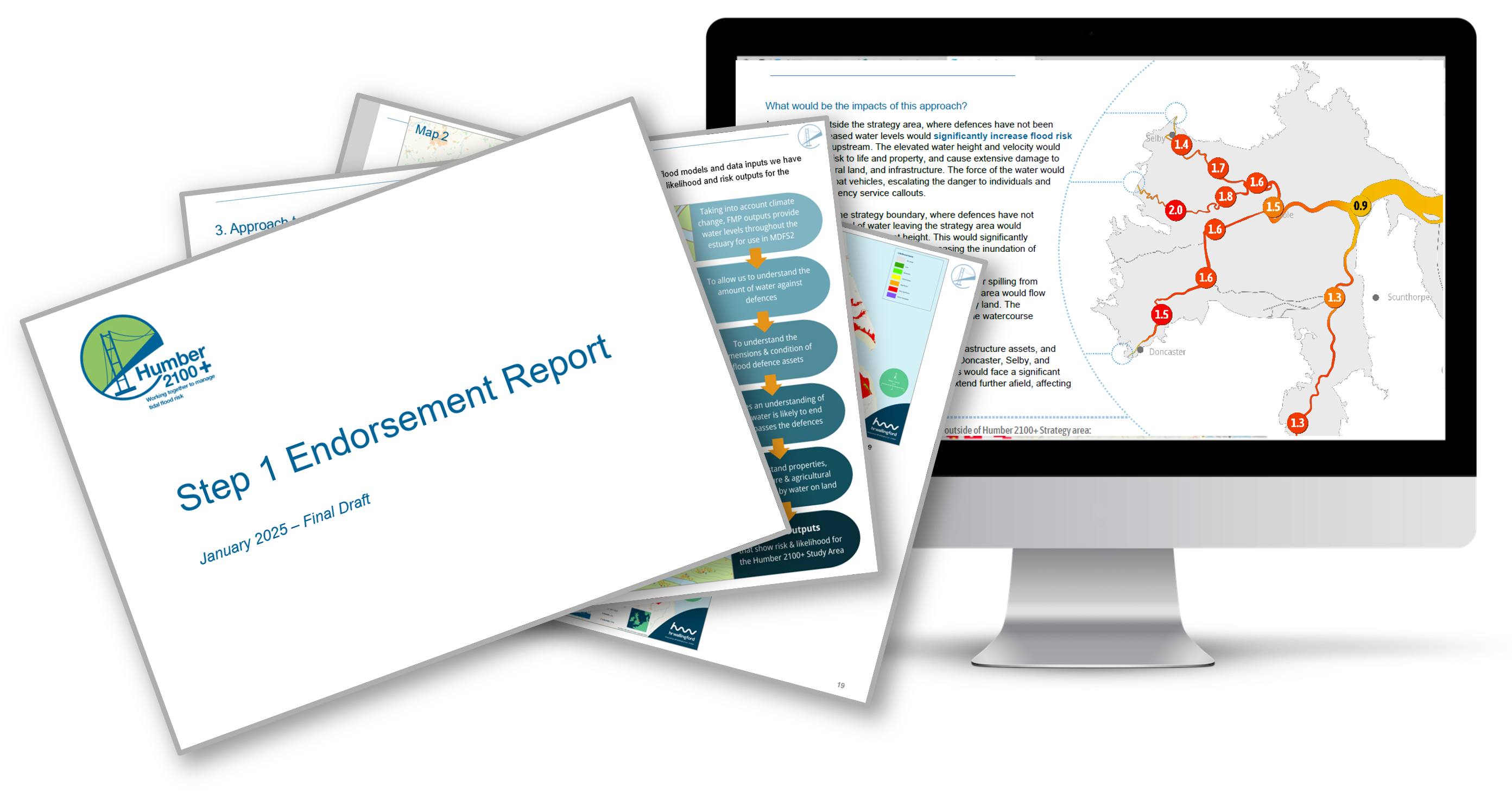
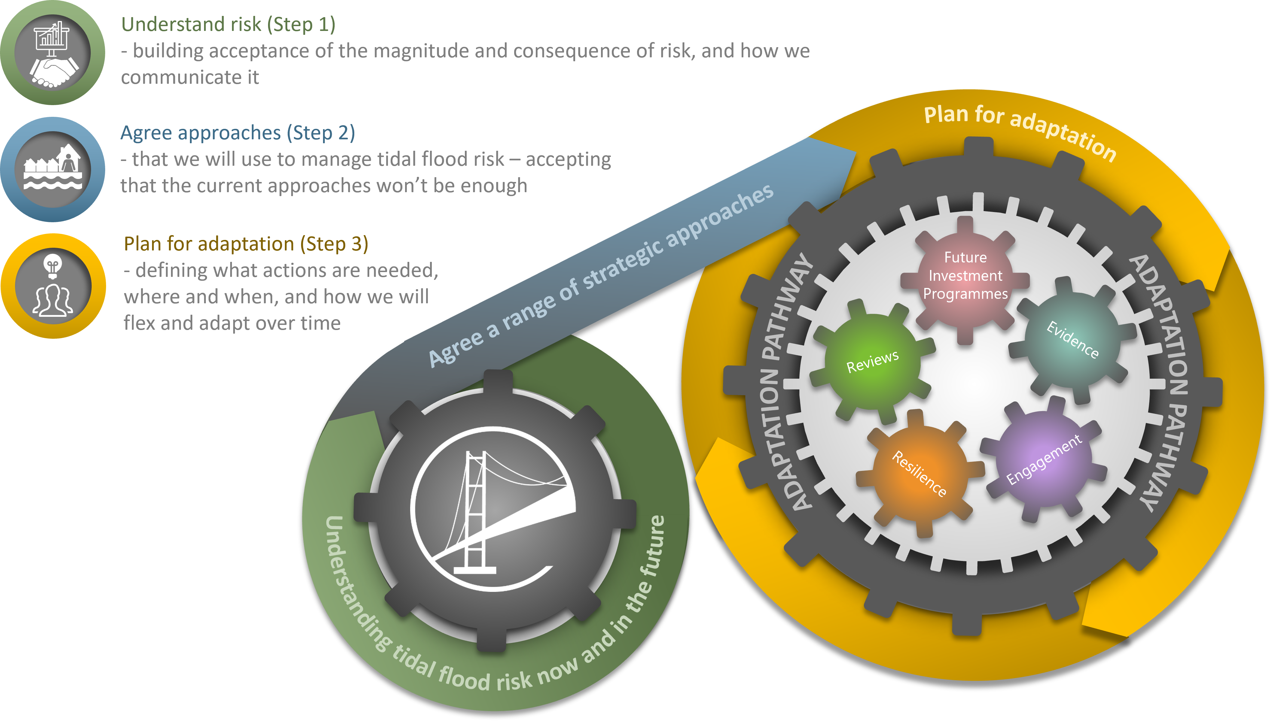
The Humber 2100+ project team have now completed the technical work for Step 1 (Understand Risk) of the project and presented the full set of outputs to partners. The 'Understand Risk' step is about building a solid foundation of evidence to create an accurate picture of future tidal flood risk around the Humber – essentially ensuring a common understanding of the challenge we face.
The outputs were presented for partner 'endorsement' via a summary report and a detailed evidence pack in January. 9 of the 11 local authority partners in the project, and the Environment Agency, have now formally endorsedContinue reading
The Humber 2100+ project team have now completed the technical work for Step 1 (Understand Risk) of the project and presented the full set of outputs to partners. The 'Understand Risk' step is about building a solid foundation of evidence to create an accurate picture of future tidal flood risk around the Humber – essentially ensuring a common understanding of the challenge we face.
The outputs were presented for partner 'endorsement' via a summary report and a detailed evidence pack in January. 9 of the 11 local authority partners in the project, and the Environment Agency, have now formally endorsed the outputs, (including the picture of risk, the methodology and data behind them). We are confident that formal endorsement from the remaining partners will follow very shortly. This is a key milestone for the project as these outputs will form the basis for understanding strategic flood risk across the Humber going forwards. They will inform Step 2 of the project, as well as shaping our ongoing investment on the ground. Having positive endorsement from all partners means that we will be able to work together on an adaptive approach to managing tidal risk across the interconnected estuary system.
Work is now underway to begin Step 2, with a number of key areas of work progressing. These include a governance review; consideration of the evidence required to ‘agree approaches’ for managing tidal flood risk; and reflections on the lessons learned from Step 1. The partnership is also working on ways to present the Step 1 outputs to the wider public.

-
Outstrays to Skeffling Managed Realignment (OtSMRS) - Pumping station and breach works resume
OtSMRS continues to attract visitors. Over the winter, there were many different varieties of birds, a diverse range of other species and visitors particularly have enjoyed the new bridleway and bird hides. Work paused during the winter to protect the over-wintering birds, but the site team have begun to remobilise enabling work to resume.
In early January, a small material slip occurred resulting in some emergency work to improve and minimise the likelihood of it reoccurring. Around the same time, the Skeffling pumping station compound was flooded due to a power cut to the existing pumping station. However, there wasContinue reading
OtSMRS continues to attract visitors. Over the winter, there were many different varieties of birds, a diverse range of other species and visitors particularly have enjoyed the new bridleway and bird hides. Work paused during the winter to protect the over-wintering birds, but the site team have begun to remobilise enabling work to resume.
In early January, a small material slip occurred resulting in some emergency work to improve and minimise the likelihood of it reoccurring. Around the same time, the Skeffling pumping station compound was flooded due to a power cut to the existing pumping station. However, there was no significant damage.
Further erosion of the breach occurred over the winter months. However, the breach still requires further expansion to better accommodate the flow of water out from the site. The MMO (Marine Management Organisation) licence has been approved and the HRA (Habitats Regulations Appraisal) has been updated to reflect this work. The works are due to be carried out in late spring/early summer when the site is likely to be drier and will better support plant movement.
The Skeffling pumping station works have resumed and should be complete by the winter. Work on Winestead pumping station (a separate Environment Agency project, being delivered under this contract with consultants for efficiency) will begin in earnest this year.
Click here to find out more about the Outstrays to Skeffling Managed Realignment site

-
Middle Humber - Capital Maintenance Programme (MH-CaMP) - progress on work packages
The project team have produced an overarching ‘Mega’ business case which was approved in July 24. The various workshops held previously have informed this work to identify key stakeholders, risks and opportunities (including environmental) to support proposed future work.
The proposal for the Middle Humber programme will start with an initial ‘bundle’ of three work packages, located on the left-bank of the Dutch River upstream of Goole and either side of the River Ouse at Reedness and Yokefleet. Currently the project team are finalising elements to be able to progress the first bundle of work. One of the key projectsContinue reading
The project team have produced an overarching ‘Mega’ business case which was approved in July 24. The various workshops held previously have informed this work to identify key stakeholders, risks and opportunities (including environmental) to support proposed future work.
The proposal for the Middle Humber programme will start with an initial ‘bundle’ of three work packages, located on the left-bank of the Dutch River upstream of Goole and either side of the River Ouse at Reedness and Yokefleet. Currently the project team are finalising elements to be able to progress the first bundle of work. One of the key projects within this programme is large scale maintenance works to the existing defences on the north bank of the Dutch River. This has been allocated £2 million Grant in Aid (GiA) funding for 25/26, with an additional contribution from the Goole Town Deal. This will significantly reduce flood risk to around 500 homes and over 300 non-residential properties. The work will be completed by March 2027.

Signup Banner
Follow Project
Follow us on social media
About the project
Why do we need a new approach for the Humber?
The Humber: A National Asset
News Categories
- Barton to New Holland (5)
- Beckingham Marshes (2)
- Dutch River (Went to Ouse) (3)
- Humber 2100+ Updates (6)
- Middle Humber (5)
- Stallingborough (4)
- The Outstrays (5)
Contact us
-
Project Team