We use cookies to ensure our site functions properly and to store limited information about your usage. You may give or withdraw consent at any time. To find out more, read our privacy policy and cookie policy.
Manage Cookies
A cookie is information stored on your computer by a website you visit. Cookies often store your settings for a website, such as your preferred language or location. This allows the site to present you with information customized to fit your needs. As per the GDPR law, companies need to get your explicit approval to collect your data. Some of these cookies are ‘strictly necessary’ to provide the basic functions of the website and can not be turned off, while others if present, have the option of being turned off. Learn more about our Privacy and Cookie policies. These can be managed also from our cookie policy page.
Strictly necessary cookies(always on):
Necessary for enabling core functionality. The website cannot function properly without these cookies. This cannot be turned off. e.g. Sign in, Language
Analytics cookies:
Analytical cookies help us to analyse user behaviour, mainly to see if the users are able to find and act on things that they are looking for. They allow us to recognise and count the number of visitors and to see how visitors move around our website when they are using it. Tools used: Google Analytics
In the Thames area we have a wide range of assets, including locks, weirs, flood defences, boat moorings and monitoring stations for air and water quality. Flood defences can include embankments, walls, flood gates and flood diversion channels. Our assets help to protect people, property, and the environment from flooding, drought and pollution.
We regularly receive enquiries about our work. This page will highlight the assets that we we receive the highest level of interest for. You will find asset information, frequently asked questions, and latest news. If you are interested in an asset not given here, please email our enquiries team.
To ensure you keep up to date about our most recent work for these sites, register with us and then subscribe to follow this page. Links to do this are in the information bar.
The Environment Agency can carry out maintenance, improvement, or construction work on main rivers to manage flood risk and protect the environment. This is done using our permissive powers under the Water Resources Act 1991. You can learn more about the Water Resources Act 1991 through this link.Any work we carry out using these powers is subject to available funding and resources.
Responsibility for maintaining main rivers ultimately remains with the riparian land owner. All watercourses not designated main river are ordinary watercourses and the Lead Local Flood Authority has similar permissive powers on these.To find out more about riparian responsibilities visit the two links below:
In the Thames area we have a wide range of assets, including locks, weirs, flood defences, boat moorings and monitoring stations for air and water quality. Flood defences can include embankments, walls, flood gates and flood diversion channels. Our assets help to protect people, property, and the environment from flooding, drought and pollution.
We regularly receive enquiries about our work. This page will highlight the assets that we we receive the highest level of interest for. You will find asset information, frequently asked questions, and latest news. If you are interested in an asset not given here, please email our enquiries team.
To ensure you keep up to date about our most recent work for these sites, register with us and then subscribe to follow this page. Links to do this are in the information bar.
The Environment Agency can carry out maintenance, improvement, or construction work on main rivers to manage flood risk and protect the environment. This is done using our permissive powers under the Water Resources Act 1991. You can learn more about the Water Resources Act 1991 through this link.Any work we carry out using these powers is subject to available funding and resources.
Responsibility for maintaining main rivers ultimately remains with the riparian land owner. All watercourses not designated main river are ordinary watercourses and the Lead Local Flood Authority has similar permissive powers on these.To find out more about riparian responsibilities visit the two links below:
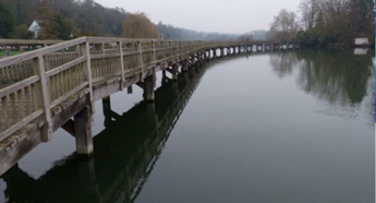
Marsh Head Horsebridge is situated near Marsh Lock, Henley, Oxfordshire. It is one of two footbridges of similar construction in this location. The bridges carry a public right of way from Henley past Marsh Lock and are part of the Thames Path National Trail.
A bridge was first constructed at the site in 1796, and the current bridge was last subject to a major refurbishment in 1996.
Keeping the public safe is one of our highest priorities and therefore following a structural inspection, we regrettably closed Marsh Head Horsebridge in May 2022 due to numerous structural and
Marsh Head Horsebridge is situated near Marsh Lock, Henley, Oxfordshire. It is one of two footbridges of similar construction in this location. The bridges carry a public right of way from Henley past Marsh Lock and are part of the Thames Path National Trail.
A bridge was first constructed at the site in 1796, and the current bridge was last subject to a major refurbishment in 1996.
Keeping the public safe is one of our highest priorities and therefore following a structural inspection, we regrettably closed Marsh Head Horsebridge in May 2022 due to numerous structural and
safety concerns.
The refurbishment of this bridge is being treated as a priority as we know how important it is to both local people and visitors using the Thames Path.
Recent Updates
To learn more about the closure of Marsh Head Horsebridge Visit this section
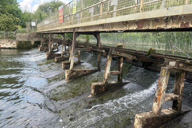
The weir walkway at Abingdon was re-opened on 30 September 2025.
Following further inspections and an assessment of the structure, procedures were put in place to identify the trigger points for the closure of the weir during high flows. When the hand radial gates are due to be operated, and the trigger point is reached the walkway will need to be closed until flows decrease.
The agreed trigger level has now been reached so the walkway unfortunately needs to be closed and the hand radial gates are in operation.
Once the flows have receded and the hand radial section ofContinue reading
The weir walkway at Abingdon was re-opened on 30 September 2025.
Following further inspections and an assessment of the structure, procedures were put in place to identify the trigger points for the closure of the weir during high flows. When the hand radial gates are due to be operated, and the trigger point is reached the walkway will need to be closed until flows decrease.
The agreed trigger level has now been reached so the walkway unfortunately needs to be closed and the hand radial gates are in operation.
Once the flows have receded and the hand radial section of the weir is no longer required to operate there will be another inspection to assess if the structure has deteriorated. If there is no visible change then the weir walkway can be reopened to the public.
The walkway supporting structure continues to need refurbishment in order to achieve its full design strength. It therefore remains at risk from impact damage during high flows.
We appreciate our customers' patience while we progress this important work and remain grateful to everyone for continuing to use the footpath diversions when the weir walkway is temporarily closed.
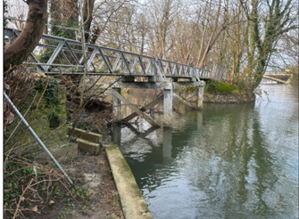
Following a tree strike in 2023 an inspection of this 90 year old bridge highlighted significant safety risks caused by cracks within the cast iron structure and one of the bridge supports.
Keeping the public safe is one of our highest priorities and we therefore closed Bridge 142 in February 2024.
We have closed a section of the Thames path, just south of the Runnymede Bridge/ M25 bridge between the Runnymede Hotel and north of Staines. There is an alternative safe route in place.
The Environment Agency is sympathetic to the concerns raised by the Thames Path organisation and theContinue reading

Following a tree strike in 2023 an inspection of this 90 year old bridge highlighted significant safety risks caused by cracks within the cast iron structure and one of the bridge supports.
Keeping the public safe is one of our highest priorities and we therefore closed Bridge 142 in February 2024.
We have closed a section of the Thames path, just south of the Runnymede Bridge/ M25 bridge between the Runnymede Hotel and north of Staines. There is an alternative safe route in place.
The Environment Agency is sympathetic to the concerns raised by the Thames Path organisation and the local community and we apologise for the ongoing disruption. We are committed to keeping everyone updated on our progress.