The River Leen Strategy
The River Leen is Nottingham’s river
Many people who live and work in Nottingham can recognise the River Leen as it crosses large parts of the city through Bestwood and Bulwell, onto Basford and Bobbers Mill, before flowing through Lenton and into the River Trent near Victoria Embankment.
The River Leen is an important and historic river. We want to make sure it stays clean, safe, and fun for everyone to enjoy!
The Environment Agency are working on a strategy to manage flood risk from the river but we also want to work with everyone who lives, works, or plays near the river.to help nature and wildlife too. When we take care of the river, it also helps the plants, animals, and people who live nearby.

The River Leen needs you!
This page will keep you updated about our plans and let you know how you can join in and help take care of the River Leen—so it stays healthy for many years to come.
The River Leen isn't just Nottingham's river, its your river and we want to know what you know and think about the River Leen. What do you like about it? Is there anything you think could make it better? Can you see the Leen from where you work or live?
You can support us by:
- Subscribing to this page for updates on our work on the River Leen.
- Leaving a short story to tell us what you think of the River Leen in our "stories" section below.
- Sending us your pictures of the Leen in our "places" section below.
- Visiting this page frequently to learn about other work you can support us with on the river.

-
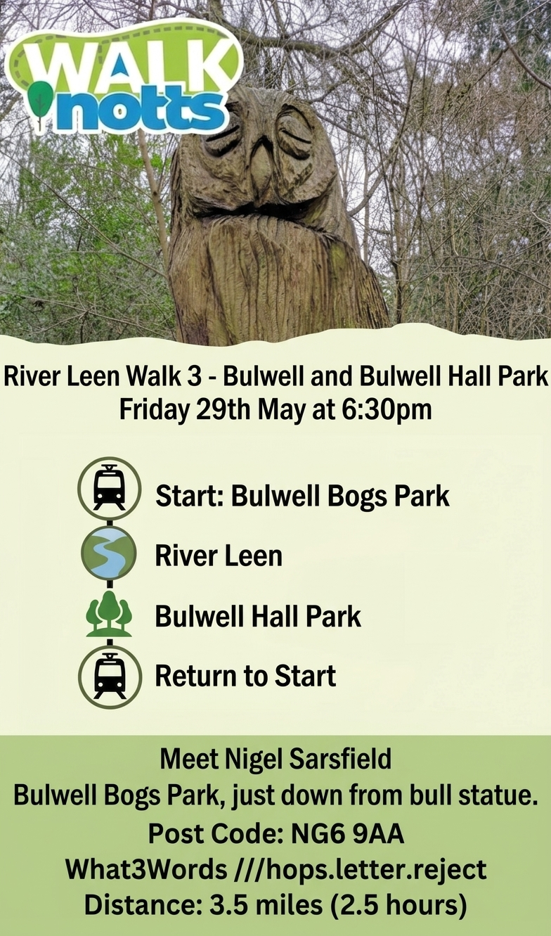
Guided walks along the Leen for national walking month
The Local Access Forum and Walk Notts are hosting a series of walks along the River Leen in May to promote National Walking Month.
Throughout the month there are a range walks taking place weekly, and special walking events provided by many groups and organisations.
Join Nigel for one or all of these walks for an excellent chance to see Nottingham's River. Details below:
-
Special Panel event

On January 28 2026 the Environment Agency, in collaboration with University of Nottingham Libraries, Manuscripts and Special Collections hosted a special panel discussion introducing the work of our River Leen team and looking at the challenges and opportunities for river management along the Leen.
The event was a great success where we shared our vision for the Leen and took questions and suggestions from a sold out crowd.
The event was filmed and a video will be uploaded onto this page soon.
-
Hillside Contingency

The Environment Agency are in the process of reviewing the condition and the future requirements of a flood risk asset in Lenton. The asset is a flood wall adjacent to the River Leen and a private car park, off Leen Gate, near the Nottingham Queens Medical Centre (QMC).
The flood wall has begun to show signs of movement and rotation that will begin to impact its function if action is not undertaken.
The flood wall forms a part of the wider River Leen Flood Alleviation Scheme that was designed and constructed in the 1960’s and 1970’s. The Environment Agency are working with Nottingham City Council to review the future flood risk needs of Nottingham and the communities and businesses that reside near the Leen. This work is the Leen Strategy and it will look at the Leen catchment and future threats and opportunities presented by the likes of climate change and adaptation to this change.
The Leen Strategy recognises that the current flood risk assets are of a significant age and the flood wall near the QMC highlights the importance of the Strategy.
Whilst the Environment Agency consider the future design and location for the replacement flood wall options, we have installed a temporary secondary flood wall, immediately behind the existing wall. The temporary wall provides the same standard of protection to the car park and surrounding hospital facilities, businesses and residential properties, should the existing wall fail.
The temporary structure is designed to take minimal space, and minimise any disruption, whilst providing a good standard of flood protection to those that depend upon the existing flood wall. Works to construct the temporary flood wall were completed in March 2026. The wall comprises concrete legato blocks, with the joints filled with a mastic sealant.
The Leen Strategy project commenced in October 2025 and is aiming to deliver outcomes and recommendations in approximately 3 years. During this time the Environment Agency will be working upon design and options for the flood wall at QMC.


-
The Leen: Nottingham's River

Presented by University of Nottingham Libraries, Manuscripts and Special Collections
Thursday 9 October 2025 to Sunday 15 March 2026
Admission is freeThis exhibition puts the Leen at the centre of the story of modern Nottingham. From its source in the Robin Hood Hills above Newstead Abbey to the River Trent at the Meadows, the River Leen connects places and communities.
Drawing on the archives of the Trent River Authority and its predecessor bodies, the materials on display show the challenges created by the growth of places like Bulwell and Basford and the expansion of industry. These included pollution fromContinue reading
Partners and Contacts
-

Phone 02030258286 Email emdenquiries@environment-agency.gov.uk -

Phone 0800 80 70 60