Dorset and Wiltshire Groundwater Incident Response 2026
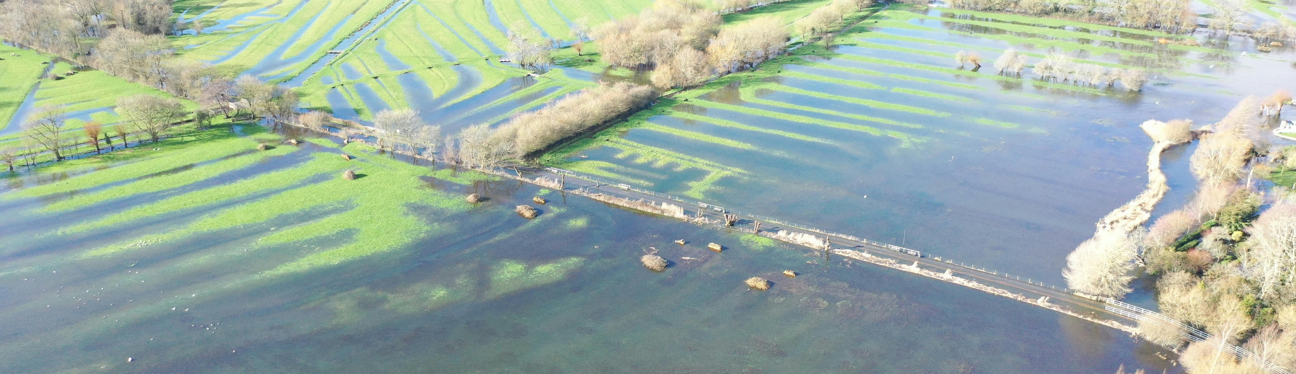
 It has been the wettest January for a lot of catchments across Dorset and Wiltshire, with the Middle Stour recording the wettest January since records began in 1891. We continued to see unsettled weather throughout February with all catchments across Dorset and Wiltshire recording over double the average rainfall.
Following heavy rain from Storm Chandra (26th to 27th Jan 2026), groundwater levels rose sharply across the Dorset and Wiltshire area, causing flooding to homes, businesses and roads networks. These levels were as high, and in some places higher, than the 2013/2014 levels that caused widespread flooding. We also saw groundwater impacts for communities that we have not seen before.
Whilst there are Groundwater Flood Warnings in force across Wessex, we will have this page live for additional information and guidance. To find out more about groundwater flooding and how it occurs, take a look at these videos: What is Groundwater?; Groundwater Animation
High groundwater levels also raise water levels in rivers and streams which makes them more reactive to rainfall. You can find the latest Flood Warnings here: www.gov.uk/check-flooding
What can you do to help / stay safe?
Staying Safe
To ensure your safety, do not walk or drive through flood water. Whilst groundwater flooding is often crystal clear, flood water may be deeper than it looks and could contain sewage and hidden hazards.
It is essential that you know what to do in the event of flooding occurring. All our guidance can be found on our Government website pages linked here:
You can check the latest river, groundwater and rainfall levels here: Find river, sea, groundwater and rainfall levels - GOV.UK
Sign up for flood warnings: Get flood warnings by text, phone or email - GOV.UK
Report and Record
We encourage you to report any property flooding as soon as you can. Reporting helps organisations coordinate support and prioritise response. You can do this by calling the Environment Agency Incident Hotline 0800 80 70 60 or directly to your Lead Local Flood Authority.
Once affected residents are able, we ask that they please submit a full report to floodreport.dorsetcouncil.gov.uk/. This tool is available for residents across Wessex (the service is hosted by Dorset Council but is available for other local authority areas). The information provided is then shared with the risk management authorities to ensure it goes to the correct organisation depending on the source and impact of flooding. If the portal opens on the wrong FORT region, don't worry, you will be redirected when you identify a property affected. Submitting a report on FORT will not trigger an emergency response
High groundwater levels can also affect sewage systems, causing backups and overflows, if you are experiencing these problems we would encourage you to report this to Wessex Water: https://www.wessexwater.co.uk/report-a-problem
Find out more
We have included some useful links for you in our information bar. This is the grey section on the right-hand side if you are viewing this page on a large screen, or at the bottom of the page if you are viewing on a mobile.
-
Dorset Community Drop Ins

-
Latest Update - 6th March 2026

Current Situation
Groundwater levels have begun to fall in some areas, and we have removed some flood warnings in places where we no longer expect flooding to properties. You can find the latest Flood Warnings here: https://check-for-flooding.service.gov.uk/
However, groundwater levels are still high, and rivers and streams remain full and will react rapidly to further rainfall. We will continue to monitor the situation and will issue further alerts or warnings if necessary.
Some properties will still need to continue to use personal property flood protection to reduce the risk of flooding from groundwater. Septic tanks may need emptying as soakaways may not work for some time.
Whilst lower severity flood alerts are still in force, the flooding of roads and fields is still possible. Flooded roads may still pose a flood risk, if vehicles create bow waves. Dorset Council are responsible for managing road closures – for the latest information: https://www.dorsetcouncil.gov.uk/travel/travel-dorset/live-travel-updates
Looking forward, levels are likely to continue to recede over the next week across the West Dorset, Cranborne Chase and Salisbury Plain areas. However, levels are still quite high so it will take time.
We will continue to work with our partners over the coming months, focussing on supporting communities to recover from this flood event.
-
Latest Update - 27 Feb 2026

Current Situation – 27 February 2026
At the time of writing, there are currently 34 groundwater flood warnings in force across the Dorset and Wiltshire area.
With a recent respite in the weather, groundwater levels have started to reduce in some areas, but many communities are still experiencing high groundwater levels and flooding. With further rainfall forecast through to Sunday, we anticipate groundwater levels to remain high.
Levels in West Dorset and Cranborne Chase are generally plateauing but remain high - with impacts still evident in many places such as Sydling st Nicholas and the Winterbournes.In Salisbury Plain, levels are generally stabilising except for the Bourne Valley where levels are still slowly increasing - but at a much-reduced rate compared to the past few weeks.
Groundwater fed rivers are still seeing higher baseflows and remain reactive to rainfall.
What next- what we will be doing.
Many communities have been affected by groundwater flooding, and we continue to be out on the ground speaking to people who have unfortunately been flooded. Although many communities are well versed in groundwater flooding, some areas have experienced this type of flooding for the first time.
There are over 14000 properties across Dorset and Wiltshire that are covered by the Environment Agency’s groundwater flood warning service, however, only around 4000 properties have signed up for groundwater flood warnings.
Please make sure you know if you’re at flood risk-flood warnings are free and easy to sign up to. You can check your overall flood risk here https://www.gov.uk/check-long-term-flood-risk and you can find the latest information here: www.gov.uk/checkforfloodingWe will be working with our partners in the months to come focussing on supporting communities to recover from this flood event.
We will continue to update this page when there is new information to report.
-
Latest update - 18 Feb 2026

Current Situation
With yellow MET office rainfall warning for Wednesday 18 February, the groundwater and rivers will continue to respond quickly to any prolonged or intense periods of rainfall; this may result in further localised flooding impacts.
We are continuing to monitor 24/7 the groundwater levels, river and rainfall.
Groundwater levels in the more reactive area of the West of Dorset remain high but are forecast to plateau this week. In the Cranborne Chase area, levels are forecast to plateau this week, whereas in the Salisbury Plain area groundwater levels are forecast to continue rising until the end of February. With an unsettled period expected there is the potential that further localised impacts to rainfall could be expected to continue until May.
Some of the communities we have visited have never experienced flooding of the extent and nature before, please check your overall flood risk here https://www.gov.uk/check-long-term-flood-risk and you can find the latest information here: www.gov.uk/check-flooding
What have we been doing?
Our staff have been out on the ground talking to affected residents over the last three weeks. We are very grateful to residents who have taken the time to speak with us, many of whom have been flooded. This information helps us understand groundwater flooding and helps to inform our flood warning timeliness and co-ordinate a response with our partners. But we will be scaling back this over the next few weeks, depending on the weather that occurs.
What you can do?
Please continue to report flooding especially if you are pumping to stop the flooding to your property. Groundwater flooding can be reported using the FORT (Flood Online Reporting Tool) https://floodreport.dorsetcouncil.gov.uk/ (available to residents in both Dorset & Wiltshire) tool or directly to your Lead Local Flood Authority (LLFA).
You can confirm on FORT how your property is affected where groundwater is rising. For example, under your floorboards, in your basement, affecting your foul drainage, road and bow waves or just affecting your access to your property. Please use the further comments for more details including pumping arrangements.
Further details on who and how to report can be found here: Report a flood or possible cause of flooding - GOV.UK
You can also report to the Environment Agency online if there are blockage on a main river, these can also be reported here: Report a blockage in a river in England - GOV.UK
Remember
Groundwater flood warnings are an opt-in service; please check your flood risk and sign up for flood warnings here www.gov.uk/get-flood-warnings
Contact Us
-
Local Enquiries

-
Contact Floodline for advice

Phone 0345 988 1188