The Project So Far
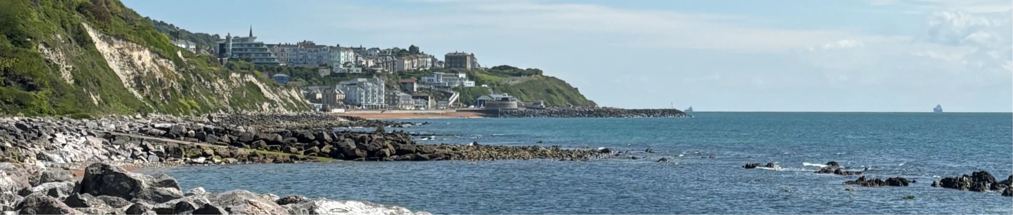
The Ventnor Coastal Protection Scheme is a collaborative initiative led by the Environment Agency in partnership with the Isle of Wight Council. This project aims to enhance coastal defences along a 3.6 km stretch from Monks Bay to Steephill Cove, addressing the challenges posed by aging infrastructure and the region's unique geological conditions.
The Ventnor Coastal Protection Scheme has been underway for some time, with a range of important investigations, trials, and planning activities taking place over the past few years.
To help you understand where we are now and what’s been achieved so far, we’ve summarised the key progress and developments below.
Key Developments to Date:
-
2021–2023: Strategic Planning
- The Strategic Outline Case was approved in Autumn 2021, allowing the project to move from early concepts into more detailed development.
- This stage focused on exploring how best to refurbish or replace existing coastal defences and improve slope stability in the areas of Ventnor most at risk from coastal erosion and landslides.
-
November 2022–2024: Emergency Works at Eastern Esplanade
- Following the failure of coastal assets in November 2022, emergency repair works were carried out at Eastern Esplanade.
- Support was provided to the Isle of Wight Council to secure funding, obtain environmental permits, and work with contractors to deliver temporary repairs that protect the seafront while longer‑term solutions are developed.
-
2023–2024: Site Investigations and Modelling
- A programme of detailed site investigations took place at Western Cliffs, Eastern Esplanade, and the promenade.
- These works included drilling, coring, and opening sections of the existing defences to assess:
- Their structural condition
- Geological characteristics
- Local groundwater and aquifer levels
- Alongside this, topographical surveys and LiDAR datawere used to model current and future coastal risks, including:
- Sea level rise
- Wave overtopping
- How the existing defences would perform if they were not raised or strengthened
-
March–May 2024: Ground Investigations and Technical Trials
- In March 2024, Phase 1 of a trial dewatering scheme was installed above the Western Cliffs to explore ways of managing groundwater and reducing ground movement.
- By late May 2024, key ground investigation works were completed at Wheelers Bay and Eastern Esplanade.
- Core samples are undergoing laboratory testing, with results expected by October 2024.
-
2024: Options Appraisal
- An options appraisal was carried out using the evidence gathered from site investigations and modelling.
- Given the complexity of the site including intertidal working, the presence of a landslide complex, and future climate pressures. The preferred approach is to use rock armour instead of conventional concrete seawalls.
- Rock armour:
- Absorbs wave energy effectively
- Has a design life of over 100 years
- Requires lower ongoing maintenance
- Adds stabilising weight at the base of the landslide system
- This approach is already successfully used at Wheelers Bay and Western Cliffs.
-
Autumn 2024–Spring 2025: Option Identification and Shortlisting
- A shortlist of technically, environmentally, and economically viable options is being assessed.
- Local knowledge and feedback are helping to shape the direction of the project.
- We continue to work closely with residents and businesses to ensure potential disruption is clearly communicated and carefully managed.
-
April 2025: Community Engagement
- A three‑day public exhibition was held at Ventnor Exchange in April 2025.
- The community was invited to:
- Meet the project team
- View artist impressions showing how the new defences could look
- Find out more about construction impacts and long‑term benefits
- A month‑long public survey was launched to gather feedback.
- Exhibition materials are available in the Documents section, and a full engagement feedback report will be published soon.
-
Mid–Late 2025: Preferred Option and Business Case
- Drawing on technical evidence and community feedback, a preferred option will be confirmed.
- An Outline Business Case (OBC)will then be submitted to secure:
- Government funding
- Planning and environmental approvals
- The scheme will be assessed for technical feasibility, environmental impact, and value for money.
-
April 2026: Landscape and Place‑Shaping Proposals
- A Landscape and Visions Opportunity Plan was developed, refined, and shared with the public.
- This plan sets out opportunities to enhance the appearance, accessibility, and character of the seafront alongside the new coastal defences, ensuring the scheme delivers wider community and environmental benefits.
-
April 2026: Outline Design Milestone Reached
- The outline designs for 15 individual seafront frontages reached 50% completion, marking a key project milestone.
- Each frontage is defined by its existing conditions and its proposed refurbishment solution.
- Once the outline designs are finalised, they will be shared publicly before being submitted for planning approval in spring 2028.

Thank you for your contribution!
Help us reach out to more people in the community
Share this with family and friends