
The Bourn Flood Risk Management Scheme
An Introduction to The Bourn FRMS
The Bourn, and its tributaries, flow through Bournville’s parks and some heavily urbanised areas before joining the River Rea in Stirchley. During periods of intense rainfall this normally calm watercourse can rapidly overtop, leading to flash flooding that affects homes, businesses, and transport links in the Stirchley and Bournville areas.
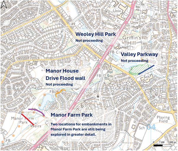
One of the most effective means to reduce flood risks is to slow the flow of water upstream by capturing water temporarily in flood storage areas during heavy rainfall. In an urban environment, opportunities to do this are limited. Initially, three potential locations were identified: Manor Farm Park, Valley Parkway and Weoley Hill.
As options of what is feasible have progressed both Weoley Hill and Valley Parkway were ruled out due to the limited space available and constraints within the parks. Since then, the focus has been on options within Manor Farm Park.
August 2026 Update
Last summer, we held public drop‑in events at Stirchley Baths and St Lazar’s Hall. These events were very well attended, and we received valuable feedback on park use and potential scheme design. This feedback was shared with our design consultants, Jacobs, to ensure local priorities and concerns were fully understood and considered.
Over the autumn and winter, we carried out more detailed assessments of the constraints and opportunities at the remaining site. This work has helped us understand what is feasible and ensure that any future scheme delivers meaningful flood risk benefits.
Key progress:
Outline and Landscape Designs Completed
Over the winter, we have continued to develop drawings and landscape plans for two potential storage locations in Manor Farm Park. These designs have been informed by a wide range of views, including those of landowners, residents at risk of flooding, park users, and professional partner organisations.
The indicative landscape plans show the view from above and include the main features of the flood storage areas. They highlight different ideas for environmental mitigation and enhancement, some of which have come from the Rea Landscape Visioning work, supported by partners. Please note these are subject to change as the project progresses. You can find these plans here.
Visualisations Completed
In response to local feedback, we have also commissioned Jacobs to produce artistic impressions of the proposed flood storage areas, link shown below. These visualisations are intended to help bring the scheme to life and show how it could fit within the park setting.
They are just indicative at this stage and subject to change as the project progresses. They are designed to show the potential views from the footpaths and give a rough idea of the scale of any features in the context of the park. We will aim to provide further drawings and visualisations with more detail as the project progresses. You can find the updated visualisations here.
It should be noted that all potential designs retain the parks as valuable green spaces for the community. The parks will remain parks and will be able to be used as they are today and for future generations to come.
Economic and Environmental Assessments Completed
Using the outline and landscape designs, we completed economic and environmental assessments during the spring. These assessments identified two economically viable options for reducing flood risk, both based on flood storage within Manor Farm Park.
These both provide significant flood risk benefits, particularly in the areas of Bournville and Stirchley. An environmental assessment was also completed to assess any impacts of a scheme and how these can be mitigated and improved within the park.
Options Appraisal Completed
We have assessed the shortlisted options using flood risk management best practice, drawing on the technical assessments and the valuable feedback received from the community. This process has identified viable options to be taken forward into the Outline Business Case (OBC). At this stage, this is likely to involve flood storage within Manor Farm Park, at one of the two locations. A properties benefitting plan can be found in the 'why is a flood risk management scheme needed' section.
Funding and Next Steps
Funding for the project remains uncertain. We currently have funding to progress the scheme through to the end of the Outline Business Case (OBC) stage. Additional funding will be required to move forward to detailed design and construction. As a result, progress is likely to pause later this year while further funding is sought.
The purpose of completing the OBC is to identify a viable proposal that delivers meaningful flood resilience for communities suffering flood risk. Now that viable options have been identified, we aim to complete the OBC later this year.
We will update this page and re‑engage with the community once funding is available to progress beyond the OBC stage.
Contact Us
If you have any questions or would like further information, please contact us at: TheBournFRMS@environment-agency.gov.uk(External link).
-
Flood Risk Management Scheme

-

-