About the sluices and our work
Background
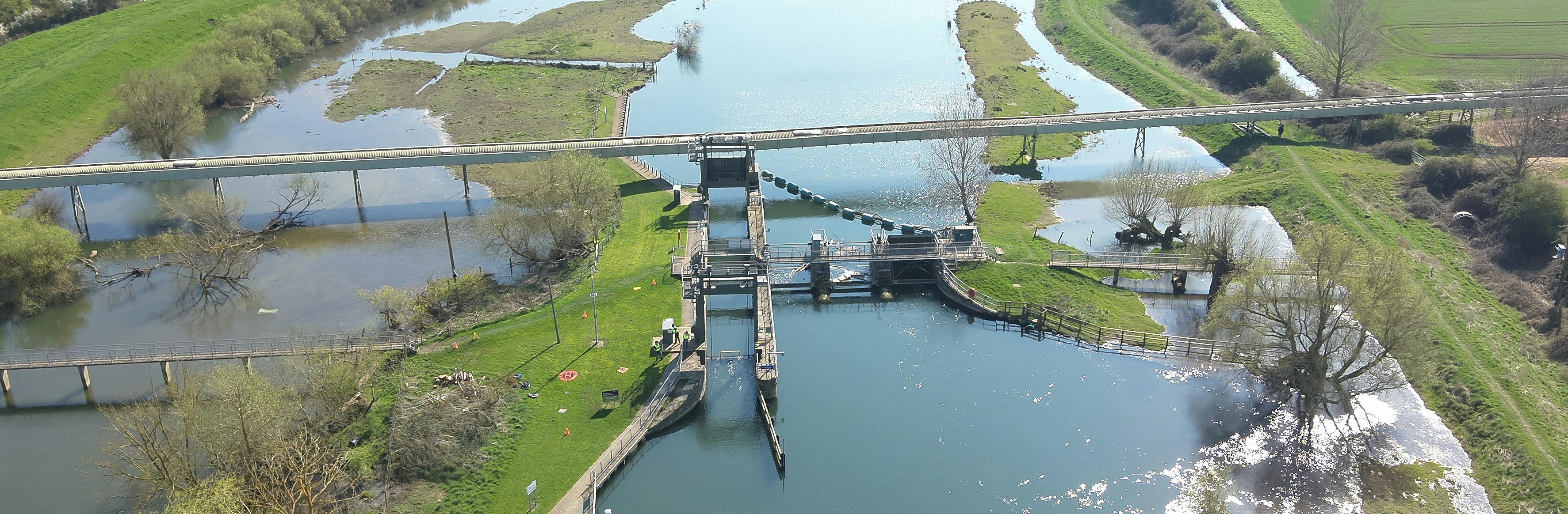
Sluices history and purpose
Both St Ives Sluices and Brownshill Staunch Sluices were originally built to maintain a navigable level of water along this stretch of the River Great Ouse.
Purpose of the sluices on Gov.uk
We are always working to improve the data on our assets and this data is made public on www.gov.uk. As a result of the latest data and evidence we now hold for these structures, we have updated the data to reflect that the primary purpose of the assets are navigation and the secondary purpose remains as flood risk.
This change has no impact on our ability to access FCRM funding, nor the rules around it.
Reasons for the sluices condition
The St Ives Sluice and Brownshill Staunch Sluice structures are in poor condition in part because they are coming towards the end of their anticipated lifespan, but also due to insufficient funding to maintain them to target condition (see below points to further expand on this question).
Legal obligations for the Environment Agency
All powers relating to flooding and land drainage are permissive. The Environment Agency has permissive powers (not a duty) to carry out flood and coastal risk management work and regulate the actions of other flood risk management authorities on main rivers and along the coast. Legal responsibility for main rivers lies with the landowners (referred to as the Riparian Owner). If the Environment Agency chooses not to exercise its powers to maintain a flood defence or watercourse, it is not liable to third parties for losses, sustained as a result.
Consequently, the Environment Agency is not legally required to maintain flood defences but can decide, as it sees fit, whether or not to carry out maintenance works and the nature of any works it carries out. Such decisions will be informed by government policy and assessment of flood risk, funding or environmental priorities.
In the area where the St Ives and Brownshill Staunch Sluices are situated, the Environment Agency does have a statutory requirement to maintain water level for navigation purposes.
These structures have a long history, originally coming to be in the 16th century, and have been funded through various routes and under various policies over the years. Historic investment in these structures may have entailed conditions around ongoing maintenance, however, the current policy supersedes any previous agreements. We must now operate within current policy and funding rules set by Government.
Funding
- All benefits arising as a result of the investment, less those valued under the other outcome measures (Outcome Measure 1).
- Households moved from one category of flood risk to a lower category (Outcome Measure 2)
- Households better protected against coastal erosion (Outcome Measure 3)
- Statutory environmental obligations met through flood and coastal erosion risk management (Outcome Measure 4)
- Approved urgent cases based on health and safety or statutory grounds and time bound partnership funding contributions
- In construction by 1 April 2025 (sub ranked by adjusted partnership funding score high to low)
- Remainder of programme ranked by adjusted partnership funding score (high to low)
Project funding
Government funding policy for capital works using Grant in Aid (GiA) changed in 2011 with the introduction of the Flood and coastal resilience partnership funding policy (partnership funding policy). This sets out that eligibility for capital Grant in Aid is calculated based on the flood and coastal erosion damages and losses avoided.
Where existing assets requiring capital interventions do not secure sufficient benefits using these criteria, they are not eligible for full funding from Grant in Aid.
All projects supported by partnership funding will need to meet specific criteria, and as a minimum in every case, demonstrate that in present value terms the expected whole-life benefits exceed the whole-life costs of the scheme.
This policy supersedes all previous grant arrangements and applies to all capital investments to refurbish, repair, replace or build new flood defences.
The Flood and Coastal Erosion Risk Management appraisal guidance manual on Gov.uk (Flood and Coastal Erosion Risk Management appraisal guidance manual - GOV.UK) provide further information on funding.
Flood Defence Grant in Aid (FDGiA)
Flood Defence Grant in Aid (FDGiA) is the central government fund for managing flood risk in England. It provides funding for EA flood risk management studies and strategies along with local authority flood risk and coastal erosion management studies and projects. The FDGiA criteria focuses on an economic assessment of costs and benefits.
What government FDGiA can fund
There are four categories under which projects can attract FDGiA. These are:
For all outcome measures, benefits in relation to any new properties (residential or non-residential) or existing buildings converted into housing after 1 January 2012 will not be counted. To qualify under OM2 and OM3, households must be permanent dwellings, e.g. not temporary or seasonal accommodation including mobile or static caravans.
Scope of government funding
The maximum amount of funding on offer to each project will be based on the value of qualifying benefits under Outcome Measures 1, 2 and 3, plus the number of environmental outcomes achieved under Outcome Measure 4, each multiplied by the relevant payment rate. Dividing this amount by the whole life costs of the project determines the share of project costs justifiable to national budgets. This is expressed as a percentage score; the PF Score.
All projects supported under this approach will need to achieve a PF Score of 100% or above. Many projects will achieve this and qualify for full funding. In other cases, cost savings and/or other sources of funding may need to be found. Both of these reduce the whole-life costs of the project to national budgets. Where a PF Score is below 100%, the deficit describes the amount of cost savings and/or contributions necessary in order for the scheme to proceed.
Assets which provide a benefit for navigation are not subject to this funding policy. However, capital funding for these assets is subject to a bid under Government spending reviews. When sufficient funding is not made available, the Environment Agency must prioritise its activities.
Grant in Aid for flood benefits and Grant in Aid for navigation benefits can be used together to fund works.
The Environment Agency secures resource funding for maintenance following a bid under Government spending reviews. It has normally been the case that the overall settlement received is less than the sum of money required to fully maintain the existing assets. The Environment Agency therefore prioritises activities in areas where the consequences of not undertaking maintenance are the greatest.
To refurbish and restore assets the Asset Recondition allocation is treated as capital and is part of the original £5.2bn capital settlement. A REC project can be defined as corrective, infrequent and a one-off activity that restores the standard of service to FCRM assets. It must be bid for in a similar way to the maintenance programme and as such assets in high consequence systems will be prioritised over assets in lower consequence systems. There is also a limit of £500k per asset and projects must not last longer than 2 years.
Limits to funding
Each year, we bid for FD GiA to fund maintenance across the catchment, including maintenance of our assets. However, we typically receive less than requested, meaning we must prioritise how the available funding is used.
To do this, each work activity is assigned a priority score based on factors such as legal obligations, activity type, and the number of properties at risk. For the Flood Risk Management System that includes St Ives Staunch Sluice (FR/02/S063), only the electric supply, eel pass maintenance, and invasive species control received GiA funding.
As a result, other activities, including Engineering & Bridge Inspections, Rope and Seal Replacement, Operational Checks, Grass Control, Tree Works, stilling well flushing, embankment topographic surveys, weed control, PSRA works, vermin control, flood gate seal replacements, and Operation & Safety improvements, were unfunded and could not be carried out. However, through catchment-wide re-prioritisation and the use of local funding sources, we are able to undertake some of these works.
Background info on funding received for 2024/25:
Nationally: £235.9m bid for, £120.3m received (£115.6m shortfall)
East Anglia: £32.6m bid for, £13.4m received (19.2m shortfall)
Great Ouse Catchment: £12.4m bid for, £4.9m received (£7.5m shortfall)
Managing capital funding for flood risk
There are certain rules we must follow to justify the investment of any public money. These rules are set by the Treasury and for flood risk investment specifically, by Defra.
To evidence the value for money that an investment provides we undertake an economic appraisal of the works we are seeking to carry out. In the case of flood risk management, it is unusual for there to be a financial return on an investment so instead, benefits are considered in terms of the value of damages and economic losses avoided due to a reduction in flood risk resulting from the investment. We need to be able to evidence that the expected whole-life benefits of a project exceed the whole-life costs.
Where projects cannot demonstrate sufficient benefits using these criteria, we are not able to spend public money on the project.
If we can evidence that a project represents value for money, we then identify how much funding a project is eligible for from Government Flood Defence Grant in Aid (FDGiA). This is calculated in line with Defra’s Partnership Funding Policy. Under this policy, the amount of FDGiA funding available for a project is based on its qualifying benefits, expressed as flood and coastal erosion damages and losses avoided. Where a project isn’t eligible for enough FDGiA to fund the whole project, Partnership funding from other sources are needed to enable the project to be delivered. Further details on Partnership Funding Policy can be found here: Partnership funding for FCERM projects - GOV.UK (www.gov.uk) (further details are also in annex 1 of this document).
The overall amount of FDGiA is limited each year and projects are prioritised by the Environment Agency on a national basis. The categories used to prioritise project bids varies from year to year, depending upon a number of different factors and the current economic climate.
At present, the national prioritisation approach is based on the principles approved by the EA Board in 2020 and Defra’s Partnership Funding Policy. The current hierarchy for allocating funding is:
Regional Flood and Coastal Committees (RFCCs) may then set local priorities with advice from other stakeholders including Lead Local Flood Authorities (LLFAs), Internal Drainage Boards (IDBs) and coastal groups, to secure additional investment from alternative sources to manage risks efficiently.
Different types of funding
Reconditioning funding allows us to restore assets to their required condition, ensuring they provide the standard of service originally intended. However, it does not allow us to extend the operational life of the asset beyond its original design span.
Moderation funding enables us to undertake high priority, legally required schemes and urgent works where there is an over-riding requirement based on either a statutory or health and safety need. Any project using moderation funding must follow the cost-effective economic approach for appraisal and therefore identify the least-cost option to solve the problem.
This means that as the works to the St Ives and Brownshill sluice structures are being funded by different funding mechanisms, the preferred option for each structure is likely to be different too
Computer modelling
- Scenario 1: All seven gates operational.
- Scenario 2: Four gates operational, three gates closed.
- Scenario 3: All seven gates closed.
Scenarios used for hydraulic modelling - St Ives
We have used hydraulic modelling in the case of the St Ives Staunch Sluice to determine the impact the structure has on flood risk. We have modelled several operating scenarios:
The modelling indicates that in Scenario 2, whilst there is an impact on river levels, no additional properties are at risk of internal flooding. In Scenario 3, one additional property is at risk in the 20% AEP (Annual Exceed Probability) and two additional properties are at risk in a larger 1% AEP event.
The modelling also indicates that the increase in river levels diminishes the further away from the sluice you go. Scenario 2 and Scenario 3 shows no impact on river levels 0.3km and 1km upstream respectively.
The output of the hydraulic modelling has also been supported by real world data collected over numerous years.
Overall, this evidence demonstrates that, based on the funding calculator we are required to use St Ives sluice, that provides limited flood risk benefit and is uneconomic. Under the current funding policy arrangements, a project would not therefore be eligible for government funding. The evidence also suggests that the current condition of St Ives Staunch Sluice is not having a significant impact on the risk of properties flooding.
Scenarios used for hydraulic modelling - Brownshill?
For Brownshill Staunch Sluice, we have modelled a similar range of options as the modelling for the St Ives Staunch Sluice, including the following operational scenarios:
• Scenario 1: All three gates operational
• Scenario 2: All three gates closed
• Scenario 3: All three gates replaced with a fixed weir
• Scenario 4: All three gates open and removed from flow
• Scenario 5: Creation of a bypass channel around the sluice.
Comparison of modelled flood levels and property floor levels show 10 properties (4 residential and 6 commercial) are at risk of flooding in Scenario 1. This includes 1 property in the 20% AEP event, 1 property in the 5% AEP event, 1 property in the 1.33% AEP event and 1 property in the 0.5% AEP event.
Properties that are already protected up to a 0.5% AEP Standard of Protection are considered “low risk” and are not eligible for government funding. This is because eligibility is based on projects achieving specified outcomes and any proposed FCERM measures will not lead to a step change in risk.
Our data also shows that in Scenario 2, whilst there is an increase in river levels, no new additional properties are at risk of internal flooding. However, for 4 (3 residential and 1 commercial) of the 10 properties identified at risk during scenario 1, the onset of flooding would be expected to occur sooner if all three sluice gates failed closed.
We are also reviewing the modelled flood levels for Scenarios 3, 4 and 5 to determine the level of flood risk associated with these options before deciding on the scope of the funding request.
Accuracy of modelling
The river modelling has been carried out using the Environment Agency’s draft Lower Ouse Model. This model is the best available modelled data we hold for the St Ives area at present.
The Lower Ouse Model, and its suitability for informing the St Ives Staunch Sluice project, has been reviewed by our National Modelling Team. Their review concluded that the model is acceptable for its purpose, determining the economic viability of carrying out a project to repair the structure.
River modelling also only forms one part of project development. When determining whether a project is viable, we assess a range of information including river modelling, costs, economic benefits, asset condition surveys, threshold surveys, property flooded information, historic flood reports and photographs of past flooding. The outputs of the river modelling have been supported by records of historic flooding, giving us further confidence in its findings and assessment of flood risk.
Further work to improve the modelling
The modelling we have has been reviewed and is considered to be acceptable for its purpose. There will always be further improvements that could be made but, in this case, we do not expect that further work would produce significantly different results and therefore would not be a good use of further investment of public money.
Project design and implementation
- investigating whether these two structures could be considered as special cases for investment given the legal obligation to maintain water levels for navigation,
- continuing to bid for maintenance funding, including for funding intended for larger scale repair works, and investigating a longer term approach which may support the use of navigation funding to support work on these structure.
Options for changing the type of structure
The Environment Agency has taken no decisions on the future of the St Ives or Brownshill structures.
Changing the sluice structures into fixed weirs would be one way of maintaining water levels for navigation with lower maintenance needs compared to sluice gates but we would need to carry out a full options appraisal to determine any future changes to the structures.
The type of funding and amount of funding we have available to us will impact on the options available to us too.
What has been done so far and looking ahead
We are investigating a number of difference angles which may enable us to carry out works on the St Ives and Brownshill Staunch Sluices, these include:
Whilst we progress these options, we are continuing our inspection regime at both structures to ensure they remain safe and to monitor their condition.
Flooding & flood risk
- Sign up for the Flood Warning Service and learn how to prepare for a flood here: Flood alerts and warnings: what they are and what to do - GOV.UK (www.gov.uk)
- Learn about what to do after a flood here: What to do after a flood - GOV.UK (www.gov.uk)
Measuring flood risk
Flood risk is communicated as a percentage of the probability of a flood event of a certain magnitude or greater, occurring in each and any one year. This is known as the Annual Exceedance Probability (AEP) and is expressed as %AEP.
For example, what used to be referred to a "1-in-100 year event" would have a 1% chance of occurring each year whilst a "1-in-2 year" event would have a 50% chance of occurring each year. The table below shows chances of occurrence against Return Period:
| Return Period (years) | Probability (AEP) | Chance of occurrence |
| 2 | 0.5 | 50% |
| 10 | 0.1 | 10% |
| 25 | 0.04 | 4% |
| 50 | 0.02 | 2% |
| 100 | 0.01 | 1% |
| 500 | 0.002 | 0.2% |
| 1000 | 0.001 | 0.1% |
To people understand the risk of flooding in a simple way, we assign risk bands to the spread of %AEP. We also provide online flood risk maps (Long term flood risk map - GOV.uk) which allow users to locate their property within the floodplain of a river. As can be seen from the table below, %AEP is spread across four ‘risk’ categories; Very Low, Low, Medium and High.
| Risk Category | Very Low | Low | Medium | High |
% AEP Band | Less than | Between | Between | Greater than |
| <0.1 | 01 to 0.99 | 1 to 3.3 | >3.3 |
How to check you risk of flooding
You can check your flood risk at Check the long term flood risk for an area in England - GOV.UK (www.gov.uk)
If you are at risk of flooding, you can:
While we undertake many different activities to reduce the risk of flooding we cannot eliminate the risk of all flooding. Alongside traditional flood defences, we need a broader range of activities to ensure we have climate resilient places. This includes avoiding inappropriate development in the floodplain, using nature-based solutions to slow the flow or store flood waters. It involves better preparing and responding to flood incidents through timely and effective forecasting, warning and evacuation.
Our data shows that the current condition of the St Ives Sluice is not causing an increased risk of internal property flooding. We expect that this is the case for Brownshill Sluice too.
Sluices impact on flood risk?
Based on the evidence we have, we do not believe that the current condition of both the St Ives Staunch Sluice and Brownshill Sluice, increases the risk of internal flooding to any additional properties.
Compensation for the impact of high water levels
We appreciate the stress and anxiety that flooding causes. However, the Environment Agency owes no duty, whether statutory or otherwise, to warn of floods or to prevent flooding and as such has no responsibility to compensate.