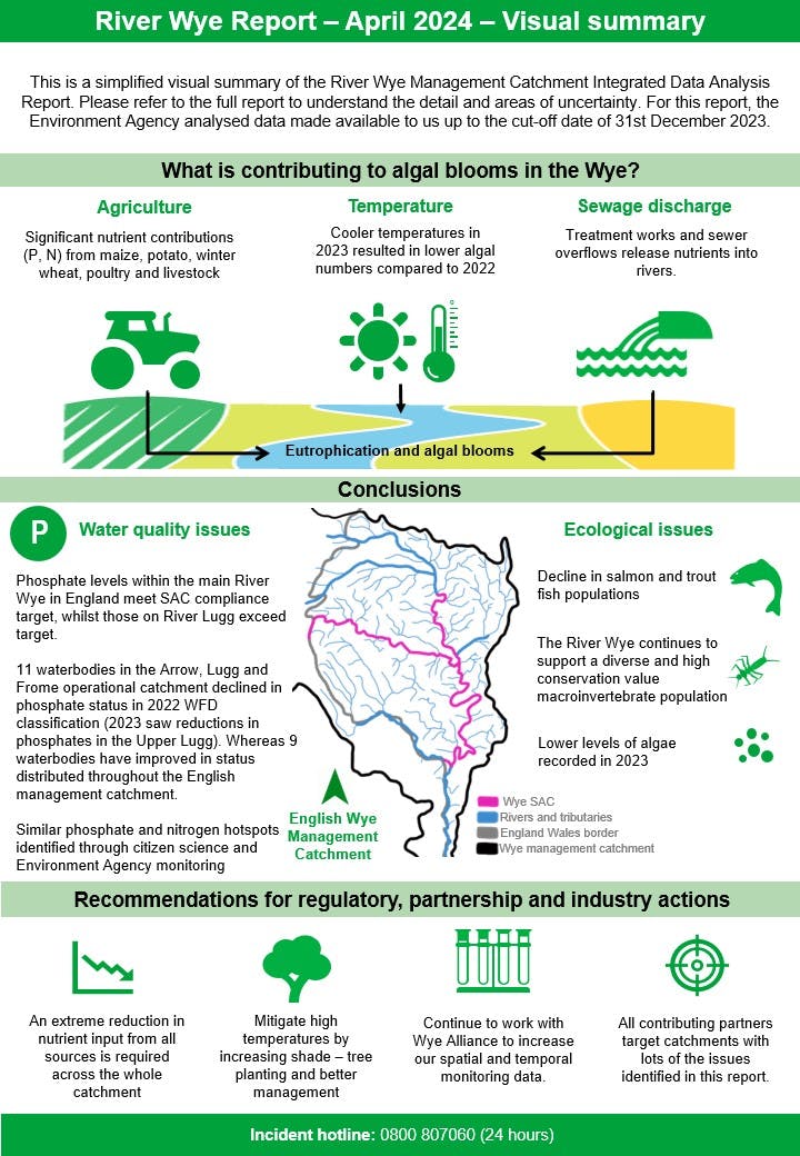
River Wye Water Quality
This page explains the importance of the River Wye, the challenges it faces, and the collaborative actions being taken to restore its health.
The River Wye is the UK’s fourth longest river, flowing 155 miles along the England–Wales border. Its rich wildlife includes otters, kingfishers, rare mussels, and iconic salmon. The river is a Site of Special Scientific Interest (SSSI) and part of a Special Area of Conservation (SAC), giving it the UK’s highest level of protection.
The Environment Agency plays a key role in improving water quality by:
- Monitoring river health and reducing pollution sources
- Protecting habitats and biodiversity
- Regulating activities impacting water quality
- Advising on sustainable development
- Coordinating catchment w‑ide action to tackle nutrient pressures

Working in partnership
The Environment Agency is a member of the Wye Catchment Partnership, formed in 2014 to bring together organisations, initiatives, and individuals committed to water quality, wildlife, and sustainable land use.
An extensive programme of advisory and support work is also being delivered through Catchment Sensitive Farming and our partners, including the the Wye and Usk Foundation, Herefordshire Wildlife Trust, Herefordshire Rural Hub and Farm Herefordshire.
Environment Agency Monitoring
The importance of data
The Wye catchment is environmentally complex, shaped by varied landscapes, rich biodiversity, and extensive agriculture. Data is essential for tackling the Wye’s environmental challenges. It reveals how land use, hydrology, and ecological factors interact and highlights key pollution sources. This shared understanding guides effective, evidence-based action. The Environment Agency are collecting data at the fastest rate ever through:
- Monitoring sondes: probes that automatically transmit water chemistry data in real time
- Autosamplers: devices that collect water samples periodically and can be triggered remotely
- Remote sensing: using drones, aerial photography and satellite images for a bird's-eye view of ground conditions
- Citizen science: research carried out by members of the public.
We also routinely monitor the ecological condition of the catchment through a variety of sampling methods and surveys, carried out at different times of the year. This wealth of information ensures that we focus our catchment-based work in the areas where it will have the greatest benefit.
Growing season monitoring
In the summer months we also collect water quality data to check water temperature and algal blooms. The data from these sondes is shared here: MDC - Meteor Data Cloud (telemetry-data.com)(External link). Further guidance on how to use the site can be found here: MDC sonde website guidance
We share this information in our Growing Season Summary Report which is an overview of our survey work in the River Wye during growing season (March to September). This report focuses on key findings from water chemistry and algae surveys and feeds into our annual Data Analysis Report, which provides evidence-based information on the ecological health of the river.
You can view all published reports on this webpage.
Citizen Science
Citizen science engages volunteers from all backgrounds in research. Over 400 citizen scientists monitor water quality along the River Wye, collecting and classifying data. Groups across the Wye catchment have formed the Wye Alliance, using consistent methods to collect and upload data into EPICOLLECT. This unified approach improves data accuracy and helps the Environment Agency better understand the catchment.
Citizen Scientists have created their own dashboard using the data they have collected which is publicly accessible via the Wye Viz platform.

-
New blog by Natural England - Assessing the Health of the River Wye Catchment: An Update

The River Wye and River Lugg are nationally important protected waterways, designated as both a Site of Special Scientific Interest (SSSI) and part of a Special Area of Conservation (SAC).
Following concerns raised in Natural England’s 2023 interim assessment, a detailed condition assessment of the River Lugg has confirmed that the site remains in an ‘unfavourable-declining’ condition. This blog outlines the findings of the assessment, highlighting the key pressures driving the River Lugg’s ‘unfavourable-declining’ status and the actions needed to support its recovery.
Read Natural England’s blog to learn more: Assessing the Health of the River Wye Catchment: An Update – Natural England
-
Release of our River Wye Data Analysis Report (2025)

We have just released our 2025 River Wye Data Analysis Report. Published annually, the report captures monitoring data from across the Wye Catchment, helping improve our understanding of the causes of changing conditions in the River Wye. Our first report was published in 2022 and all reports can be found on this page.
You can view the full report here: 2025 River Wye Data Analysis Report and a summary of the report findings here: 2025 River Wye Data Analysis Report - Summary
-
Watch project updates via Nutrient Management Board recording

The Wye Catchment Nutrient Management Board held on 29 April included a variety of speakers sharing updates from significant projects in our catchment.
The recording is now available so you can hear directly from those involved in the projects. This includes:
The University of the West of England (UWE Bristol) - Dr Rounaq Nayak (UWE Bristol) outlining the approach to the new £1million research project
Nutrient Balance Project - Dan Smith (Herefordshire Rural Hub) on the outcomes of the nutrient balance analyses
Unlocking Soil Legacy Phosphorus: Improving Nutrient Management through Total Phosphate Soil Testing in the Wye Catchment - Kate Speke-Adams (Herefordshire Rural Hub) on total phosphate testing in the Wye catchment.
You can watch the full recording on YouTube at Wye Catchment Nutrient Management Board - Wednesday 29 April 2026 2.00 pm, where you’ll find the different topics are listed below the video. Simply click on the talks that you want to watch.
-
Could citizen scientists help document spatial and temporal change in filamentous algae? A case for the River Wye
 In this article, FBA Fellow Martyn Kelly, Environment Agency biologists Jason Doe and Luke Walters, and former FBA Chief Executive Bill Brierley reanalyse a dataset from the River Wye to document spatial and temporal variation in the attached algae, and what this means for managing this iconic river.
You can view the article here: Could citizen scientists help document spatial and temporal change in filamentous algae? The case of the River Wye. — Freshwater Biological Association
-
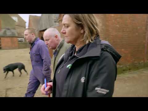
What should you expect from a farm inspection?

We have released a video on 'What should you expect from a farm inspection' that can be viewed here: https://www.youtube.com/watch?v=fITrOFMMv3Y
The Environment Agency inspects farms in the Wye catchment to reduce agricultural pollution and protect the river’s water quality. Inspections ensure compliance with environmental regulations such as the Farming Rules for Water, address nutrient runoff, and help protect the River Wye’s Special Area of Conservation status. The EA also uses inspections to gather evidence, enforce standards, and support more sustainable farming practices.Our officers work with with farmers to help them manage the above and work together to improve theContinue reading
RePhoKUs - 'Focus on Phosphorus' video series
-
 This episode explains the relevance of Phosphorus within the catchment and the challenges that come with its use.
-
 This episode explores who we are working with and how we are working together to restore the River Wye.