FAQs
Am I at flood risk?
Am I at risk of flooding?
Flooding can happen during drought - don't be caught out
Extreme weather is becoming more common in the UK due to climate change, bringing more frequent and intense events like flooding. Despite a dry summer, communities are urged not to ignore the risk.
Around 6.3 million properties in England are in flood-risk areas, and the threat is growing. Last winter, the Environment Agency issued thousands of flood alerts and warnings.
Yet only 45% of people say they understand how to protect their homes. It’s vital that everyone knows their flood risk and how to prepare.

The dangers of delaying action
Flooding can have a devastating impact, so protecting people and communities is a top priority. Being prepared can reduce damage to homes and businesses, lowers risk to life, and helps prevent future mental health impacts.
To find flood protection products like flood doors and airbrick covers, visit http://www.bluepages.org.uk. You can also use simple alternatives like placing soil-filled bags across doorways or drains.

Surface water flooding
Surface water flooding happens when rain can’t drain away properly and instead pools or flows over the ground.
Lead Local Flood Authorities (LLFAs) manage this risk by working with the Environment Agency, councils, drainage boards, and water companies.
For more details on surface water flooding, visit: https://www.gov.uk/government/publications/flood-risk-maps-for-surface-water-how-to-use-the-map or contact your local authority or drainage board for local flood information.
Ground water flooding
The Lead Local Flood Authority (LLFA) are responsible for managing the risk of groundwater flooding. This can occur when periods of prolonged rainfall cause the water table to rise and emerge in basements or above ground.
For more information about ground water flooding, visit: https://www.environmentagency.blog.go.uk/2019/12/23/what-is-groundwater-flooding
Additionally, please find Darcy’s Tale here: https://www.youtube.com/watch?v=/iZELzck692s and visit: https://www.letstalkgroundwaterflooding.org
Know how to Prepare. Act. Survive.
The good news is that preparing for flooding includes simple things that you can do to help keep you, your home, family and business safe and save you thousands of pounds in damages and disruption. The below infographic sets out some of the steps you can take.

Find out if your area is at risk of flooding and the current alerts and warnings that have been issued here www.gov.uk/check-flooding or call our Floodline service on 0345 988 1188. Sign up for flood warnings here: www.gov.uk/get-flood-warnings
Links you may find useful:
Do I own a watercourse?
Do you own a watercourse?
What is a watercourse?
A watercourse can be any stream of water flowing in a defined channel or through an underground pipe or culvert. It can be small or wide, natural, or artificial and includes channels that are dry for long periods of time and may not flow every year. A dry channel only filled during temporary flooding is not a watercourse.
Some watercourses in England are designated as ‘main rivers’. These tend to be larger rivers and streams with the highest flood risk, although in some cases they can be small watercourses or drainage channels. The Environment Agency, using its permissive powers, can carry out maintenance, improvement, or construction work on main rivers to manage flood risk and protect the environment. As these powers are permissive only, the Environment Agency is not obliged to carry out either maintenance or new works on main rivers. The Environment Agency also has permitting and enforcement powers for the same purpose.
For all other watercourses, called ‘ordinary watercourses’, similar powers lie with the lead local flood authority, local council, or internal drainage board. To find out who your local council is go to: www.gov.uk/find-local-council To find out if there is an internal drainage board in your area, go to: www.ada.org.uk/member_type/idbs
Do I own a watercourse?
Land ownership can be a complex topic, including whether you own a watercourse. It is sometimes unknown, disputed, or difficult to work out, even when looking at title deeds for a property.
The following diagram shows the typical circumstances in which you are classed as a riparian owner for a stretch of river or other watercourse.
To find out who owns parcels of land, contact the Land Registry who hold most records: https://www.gov.uk/get-information-about-property-and-land To find out if you own a main river, see the website here: https://environment.data.gov.uk/asset-management/
A person leasing riparian land will also have riparian responsibilities, unless an agreement to the contrary has been made with the landowner.
You can also find out more about riparian ownership, for both main river and ordinary watercourses, on the Flood Hub’s ‘Riparian Owner Toolkit’ website: https://thefloodhub.co.uk/riparian-owner-toolkit

Diagram 1 - An example of the typical circumstances in which you are classed as a riparian owner. Diagram 1 shows two streams flowing into a large river. Houses are labelled A, B and C and a row of houses is labelled D to show different riparian responsibilities.
Check your property deeds as hedges, fences and earth banks may not signify your legal boundaries.
A. Property A is responsible for the watercourse which runs through their property. They also own up to the centre of the watercourse that runs along their property boundary to the south.
B. Property B is not a riparian owner as their property boundary does not extend to the watercourse.
C. Property C is responsible for the watercourse to the rear of their boundary, extending to the central line. They are also responsible for the stream to the west of the property up to halfway across the watercourse.
D. A watercourse may also be covered or ‘culverted’. Properties D are riparian owners and responsible for the culvert running beneath their properties, as shown by the dashed blue line.
Where a river runs along the boundary of land, the riparian owner will own up to halfway across the watercourse, unless stated otherwise in property deeds.
What are my rights and responsibilities?
As a riparian owner, you have responsibilities for the stretch of watercourse you own. These responsibilities cover all watercourses and are summarised further in 'Your Watercourse: rights and roles' found here: https://www.gov.uk/guidance/owning-a-watercourse.
As a riparian owner of a ‘main river’, you have various rights in terms of access to and use of that water. However, all these rights are subject to legal requirements. To fully exercise these rights, permits or licences may be needed from the Environment Agency or other public bodies. Please refer to 'Your Watercourse: rights and roles' document and find ‘Do I need permission?’.
Where the watercourse is an ‘ordinary watercourse’, you also have various rights in terms of access to and use of that water. For information on any permits or licences required to exercise these rights, contact your lead local flood authority or internal drainage board.
Who can I contact for more information?
If you would like further information on riparian ownership, please use the contact details below:
Post - National Customer Contact Centre PO Box 544 Rotherham S60 1BY United Kingdom
Email - LNenquiries@environment-agency.gov.uk
Telephone - 03708 506 506 (Monday to Friday, 8am-6pm)
Incident Hotline - 0800 80 70 60 - to report flooding, blockages, pollution, unusual changes in flow of water, collapsed or badly damaged defences (24-hour service).
How do our assets work?
How do our assets work?
England has around 255,700 flood risk management assets, and we maintain about 90,200 of them. These include embankments, pumping stations, and control gates that help manage water and reduce flood risk.
Not all assets serve this purpose—many support navigation, water quality, and biodiversity.
People often ask, “What is a flood gate?” or “What does a weir do?” Our aim is to help you understand how these assets work and the role they play in keeping communities safe. Below are some common examples of flood risk management assets you may see in your community.
To explore more assets, paste the following in your web browser: https://environment.data.gov.uk/asset-management/ Please note, this page is updated at key intervals.
You will arrive on the page below. Click 'Data Requirements Library' found top right on the page (circled red):

From here, left click a 'blue' item on the map and a list of assets will pop up for you to choose from:

Left click on an asset you would like to look at. Then left click on 'View asset type in Data Requirements Library:


How do we prepare for flood incidents?
How do we prepare for flood incidents?
Our Asset Performance play a key role in preparing for and responding to flood incidents. Our focus is ensuring that flood risk assets - such as flood embankments, flood walls, sluices, pumping stations, outfalls, and reservoirs - are ready to perform when needed.
What we do and why
We prepare for incidents by carrying out regular inspections, surveys, and condition assessments of flood risk assets to identify defects, monitor asset condition, and address potential risks before an incident occurs.
We manage and review information within our asset management systems, ensuring decisions are based on accurate, robust, and up-to-date data, which helps prioritise maintenance activities and investment in the assets that are most critical to reducing flood risk.
This information is used to develop and deliver programmes of maintenance, refurbishment, and asset replacement to ensure flood defence assets remain effective, reliable, and capable of reducing flood risk to communities.
We undertake regular training to maintain the competencies required for formal incident response roles, such as Flood Incident Duty Officer, ensuring they can effectively support and manage the response during flood events and other emergencies.
We have a 24/7 standby to respond to incidents. We use the forecast to scale up our incident response ahead of time, so we are ready.
During flood events, we work with our Field Teams to operate and monitor flood risk assets, helping deliver a tactical and operational response alongside other emergency responders.
We work with our other internal teams to maintain relationships with local authorities, flood groups, and other risk-management authorities to improve preparedness and coordinated response.
Who can I contact for more information?
If you would like further information about how we prepare for flood incidents, please use the contact details below:
Post - National Customer Contact Centre PO Box 544 Rotherham S60 1BY United Kingdom
Email - LNenquiries@environment-agency.gov.uk
Telephone - 03708 506 506 (Monday to Friday, 8am-6pm)
Incident Hotline - 0800 80 70 60 - to report flooding, blockages, pollution, unusual changes in flow of water, collapsed or badly damaged defences (24-hour service).
Funding FAQs
What are flood risk management systems?
What are flood risk management systems?
Flood Risk Management Systems (FRMS) are our way of grouping together flood risk management assets and related structures that work as a system to reduce flood risk in a specific place. An FRMS can include things like flood walls and embankments, river channels, and tidal or coastal defences.
The systems focus on flooding from main rivers and the sea. They do not usually include smaller ordinary watercourses, sewers, or surface water flooding.
Each FRMS covers a defined geographical area e.g. a particular community, town, or stretch of land. It is treated as a single system, rather than individual assets in isolation. This helps us to monitor how well flood risk management assets are performing, decide where maintenance or improvements are most needed, justify investment and public spending, and measure the benefits of flood risk work over time.
How are FRMS areas defined and rated?
FRMS boundaries are based mainly on natural features, such as river catchments and coastlines. The rules are designed to keep FRMS areas stable and consistent, so changes in flood risk and performance can be tracked over many years without confusion.
We give each FRMS a consequence rating: High, Medium or Low, to help us prioritise our work. The rating is decided by looking at the risk to people, homes, businesses, and land. In simple terms, the higher the potential risk to people or homes, the higher the consequence rating.
How do FRMS influence where we spend our funding?
Our asset maintenance funding focuses on preventing deterioration and prioritising repairs to critical flood and coastal assets to ensure they operate effectively during flood events and reduce the risk of failure.
Maintenance funding is prioritised nationally using consistent criteria, focusing on legal obligations and the greatest flood risk reduction for people, homes, and businesses. Funding is distributed across England with flexibility for local needs, and Regional Flood and Coastal Committees advise on priorities and can influence additional funding, including local levy contributions.

The map shows the Lincolnshire and Northamptonshire high, medium, and low consequence FRMS. The green and red pie charts represent the proportion of allocated funds available for these systems for this financial year (2026/27) as a total of the amount bid for. Green is the portion where funds have been allocated, red is unallocated, and therefore a shortfall in funding.
Where Low consequence systems have a full green pie chart (100% funded) these are generally due to various maintenance obligations which we must fulfil. They can range from legal obligations (such as land ownership), environmental (areas like SSSIs or Eel passes) to Reservoir obligations.
You may see a full red circle (100% Unfunded) in a high consequence FRMS. This implies that the Cost:Benefit ratio for that system is not sufficient to attract any funds from the National Allocation. There is a legend at the bottom of the map.
Why this matters to you?
FRMS enable to put public safety first, prioritise our funding, and manage flood risk consistently.
Who can I contact for more information?
If you would like further information on Flood Risk Management Systems, please use the contact details below:
Post - National Customer Contact Centre PO Box 544 Rotherham S60 1BY United Kingdom
Email - LNenquiries@environment-agency.gov.uk
Telephone - 03708 506 506 (Monday to Friday, 8am-6pm)
Incident Hotline - 0800 80 70 60 - to report flooding, blockages, pollution, unusual changes in flow of water, collapsed or badly damaged defences (24-hour service).
What is General Drainage Charge Local Levy and Internal Drainage Board Precept?
What is General Drainage Charge, Local Levy, and Internal Drainage Board Precept?
General Drainage Charge
The General Drainage Charge (GDC) is a statutory charge that applies to occupiers of agricultural land and buildings in the Anglian area that fall outside Internal Drainage Board (IDB) boundaries. It helps pay for local flood-defence work such as maintaining main rivers, sea defences, and tidal embankments. It only applies in Lincolnshire, Northamptonshire, and East Anglia, and is separate from charges made by IDBs or Internal Drainage Districts (IDDs).
Local Levy
The Local Levy is a local funding source raised through Council Tax and used only within the region. It helps boost partnership funding and bring in extra government funding, it allows some projects to start sooner, and it funds flood-risk projects, studies, monitoring, and community work across the region. It funds a range of schemes, including coastal protection, tidal and sea-flood resilience, main river and surface-water flood schemes, and Natural Flood Management. Support from the Anglian Northern Regional Flood and Coastal Committee in financial year 2025 and 2026 supports us to carry out routine maintenance at more locations, going beyond what central funding alone would allow.
IDB Precept
The Environment Agency can require IDBs to contribute money each year through an IDB precept. This mainly supports maintenance work but can also fund wider flood and coastal-risk activities. In larger programmes, some of the funding may cover staff costs to manage the work, as long as it benefits the region it comes from. The Environment Agency also raises money through IDB precepts, GDC and selling assets.
Why is maintenance not guaranteed in specific locations or for individual landholdings?
Levies are not payments for specific works on a particular field or holding. Instead, it is a contribution toward the wider management of water levels and flood risk across the catchment.
Therefore, even where no direct intervention is planned on a specific piece of land, that land still forms part of the hydrological system that benefits from the overall management of watercourses, flood defences, and strategic planning undertaken in the area.
Levies are not linked to a promise of maintenance on any specific stretch of watercourse or any individual property. Work is prioritised based on risk, environmental need, and available resources across the whole catchment, not on a land-by-land basis.
This means that:
• No individual landowner is guaranteed maintenance
• Benefits may be indirect or strategic rather than visible on-site
• Timetables for intervention depend on catchment-wide priorities rather than individual holdings
How are the charge, levy, and precept fair and proportionate?
The GDC is set each year by the Regional Flood and Coastal Committee (RFCC) and applied at a uniform per-hectare rate to all chargeable land in the Anglian area, ensuring occupiers contribute in proportion to the land they hold. Its fairness comes from using one transparent rate for all eligible land, operating within a statutory framework that restricts spending to flood and water management. This recognises that all land within a catchment both contributes to and benefits from the wider drainage system, even if the benefits are not specific to each site.
Local Levy is a local funding source set by RFCCs to support priority flood and coastal risk projects that national funding doesn't fully cover. Spending must show good value for money, align with national and local FCERM priorities, and maximise flood-risk benefits. The RFCCs must manage funds flexibly and fairly to meet regional needs. Local levy funding must be spent within the RFCC region it was raised in. It does not have to be spent in the same year. RFCCs usually maintain a balance of local levy funding.
An IDB precept must be spent in the year it is raised and cannot be carried forward, unlike Local Levy. The Environment Agency requires RFCC consent for both the level of precept and the programmes it will fund, meaning RFCC views directly shape how precept income is used. Precept is mainly used for revenue maintenance, but it can also support wider flood and coastal risk work when needed. In larger programmes, a small portion may be used for staff costs to manage and report on the work, provided this benefits the flood-risk region where the precept was raised.
Who can I contact for more information?
If you would like further information on riparian ownership, please use the contact details below:
Post - National Customer Contact Centre PO Box 544 Rotherham S60 1BY United Kingdom
Email - LNenquiries@environment-agency.gov.uk
Telephone - 03708 506 506 (Monday to Friday, 8am-6pm)
Incident Hotline - 0800 80 70 60 - to report flooding, blockages, pollution, unusual changes in flow of water, collapsed or badly damaged defences (24-hour service).
Our legal obligation maintenance FAQs
How do Asset Performance teams manage water?
How do we use our assets to manage water?
Our flood risk management assets are wide and varied and we use these to manage water as it flows through rivers towards to the sea. The way that we manage water depends on where it is.
In the upstream areas of rivers, measures such as natural flood management measures that can store and slow water running of land after rainfall are used. These help to reduce river levels and therefore flooding downstream.
The water levels on most rivers in Lincolnshire and Northamptonshire are controlled by a series of sluice gates and weirs. Under normal conditions these maintain water levels to regulate flow, hold water for navigation and recreational purposes, or for water abstraction and biodiversity needs.
How do we measure water to operate our flood risk assets?
In the Environment Agency, our teams maintain, manage, and calibrate our monitoring stations. These stations take vital hydrological measurements, including river levels, river flows, rainfall, and groundwater levels.
As well as the sensors that collect the data, we also use field telemetry systems (waterproof computers) that send crucial data back to the office. Teams validate the data and use this to respond accordingly to any issues in the watercourse such as significant rainfall or prolonged dry weather. Examples include closing the Boston Barrier to prevent high tides flowing into Boston Town, opening the Surfleet Sluice gates to reduce retention in anticipation of high rain and during tide locks, or closing sluices to hold water levels in river sections where possible in times of drought. Our live data is available here: https://check-for-flooding.service.gov.uk/river-and-sea-levels for the public to access, so local river levels, flood risk and environment can be monitored.
While we cannot control the weather, our flood risk management assets and the way we operate them, helps to reduce the risk of flooding. When they work together, homes and businesses are better protected, water moves through rivers to where it is needed, and communities can spend time enjoying rivers and waterways.
Who can I contact for more information?
If you would like further information on riparian ownership, please use the contact details below:
Post - National Customer Contact Centre PO Box 544 Rotherham S60 1BY United Kingdom
Email - LNenquiries@environment-agency.gov.uk
Telephone - 03708 506 506 (Monday to Friday, 8am-6pm)
Incident Hotline - 0800 80 70 60 - to report flooding, blockages, pollution, unusual changes in flow of water, collapsed or badly damaged defences (24-hour service).
What is a Flood Storage Reservoir?
What is a Flood Storage Reservoir?
A Flood Storage Reservoir (FSR) is a basin or large area designed to temporarily hold floodwaters and reduce the risk of flooding downstream. Unlike water supply reservoirs, many FSRs remain dry most of the time. They appear as farmland, parks, or meadows and only fill during heavy rainfall or flood events.
FSRs must comply with The Reservoirs Act 1975. The Act ensures adequate safety in the design, construction and operation of a Flood Storage Reservoir.
Most of our FSRs are high risk Large Raised Reservoirs (LRR). These reservoirs can hold more than 25,000 cubic metres of water above natural ground level. Smaller reservoirs are known as Small Raised Reservoirs (SRR) and can hold 10,000–25,000 cubic metres of water. While SRRs are not yet fully regulated under the Act (non-statutory), future legislation may extend safety requirements to them due to the risks they can pose.
Why are Flood Storage Reservoirs Important?
FSRs are a critical part of the UK’s flood risk management strategy. Their primary role is to protect people, property, and infrastructure by storing excess floodwater. They do this by managing the increasing risks of extreme rainfall and flooding due to climate change. They also provide wider benefits such as wildlife habitats, green spaces, recreation, and water quality improvements.
The time it takes for a FSR to release floodwater is influenced by several factors that include how much water has been stored, tidal cycles where relevant, and further rainfall events. In some instances, some low-lying areas in the FSR could take months to drain. Therefore, we cannot guarantee when water will have receded from different parcels of land within the FSR area.
Water Resources Act 1991
The Water Resources Act 1991 is the primary legislation relating to water resources activities. It sets out the requirements for abstraction and impounding (containment) licences when water is removed from a waterbody or when the flow in a waterbody is impounded, impeded, or obstructed. The Water Resources Act made the Environment Agency the enforcing authority for England.
Nationally, over 75% of reservoirs were built before 1900. It is critical that the Environment Agency ensures the safety of old structures and maintains the standards of new ones. In comparison in Mainland Europe, only 10% are over 100 years old.
Our FSR Undertaker Duties
There are 14 recorded dam failures in the UK in the 19th century with a loss of 427 lives. This resulted in the need for legislation. Since the introduction of the Reservoirs (Safety Provisions) Act in 1930, there have been no failures involving loss of life. Various revisions have ultimately resulted in Reservoirs Act 1975.
In relation to the Reservoirs Act 1975, we are deemed the ‘Undertaker’ for Flood Storage Reservoirs managed and operated by us. We are the undertakers of 222 reservoirs in England.
As an undertaker for these reservoirs, we are responsible for their safety under the provisions of the Act, including appointing qualified civil engineers.
Maintenance
Our Field Teams and contracted partners carry out regular maintenance on our Flood Storage Reservoirs. Some landowners and tenants may also have maintenance responsibilities if they have Riparian Owner responsibilities. Maintenance often includes several yearly grass cuts including inspections for damage by burrowing animals and embankment erosion, ensuring operation of any fish and eel passes on the flood storage reservoir, inspections of concrete and masonry structures, hydraulic controls, and safety inspection equipment, and security of the site.
To find out more about the design, operation, and adaptation of reservoirs for flood storage, please visit: https://www.gov.uk/flood-and-coastal-erosion-risk-management-research-reports/design-operation-and-adaptation-of-reservoirs-for-flood-storage
You can find further information about safety inspections of reservoirs here: https://www/gov.uk/guidnace/reservoir-inspecting-engineers-safety-inspection-of-reservoirs
Who can I contact for more information?
If you would like further information on riparian ownership, please use the contact details below:
Post - National Customer Contact Centre PO Box 544 Rotherham S60 1BY United Kingdom
Email - LNenquiries@environment-agency.gov.uk
Telephone - 03708 506 506 (Monday to Friday, 8am-6pm)
Incident Hotline - 0800 80 70 60 - to report flooding, blockages, pollution, unusual changes in flow of water, collapsed or badly damaged defences (24-hour service).
What are Asset Performance teams' legal obligations?
What are Asset Performance Teams' legal obligations?
Our Asset Performance teams have several maintenance activities that we have a legal obligation to complete each year. We must meet health and safety obligations to ensure our assets are safe for or workforce and the public, and meet relevant habitat obligations.
Eel Passes
The European eel is now critically endangered, with severe declines across the UK and Europe. To address this, the UK introduced the Eels (England and Wales) Regulations 2009, creating a legal duty to protect eel populations.
Fish Passes
Man-made structures can block fish movement, harming populations and preventing access to essential habitats. Because of this, ensuring fish passage is a legal requirement under legislation such as the Eels Regulations 2009 and the Salmon and Freshwater Fisheries Act 1975.
These laws require us to ensure safe passage for fish and eel migration, habitat access, and population resilience. It is a legal offence not to install and maintain eel screens on certain water intakes unless exempted. We have powers to enforce modifications to structures that obstruct fish and eel movement.
Reservoirs
The Reservoirs Act 1975 places legal duties on reservoir owners (undertakers), and failure to comply is a criminal offence.
To meet this obligation, as undertakers we must appoint qualified engineers to inspect, supervise, and manage reservoir safety, and must carry out and fund any statutory inspections, safety works, and maintenance identified.
Who can I contact for more information?
If you would like further information on riparian ownership, please use the contact details below:
Post - National Customer Contact Centre PO Box 544 Rotherham S60 1BY United Kingdom
Email - LNenquiries@environment-agency.gov.uk
Telephone - 03708 506 506 (Monday to Friday, 8am-6pm)
Incident Hotline - 0800 80 70 60 - to report flooding, blockages, pollution, unusual changes in flow of water, collapsed or badly damaged defences (24-hour service).
Our regular maintenance FAQs
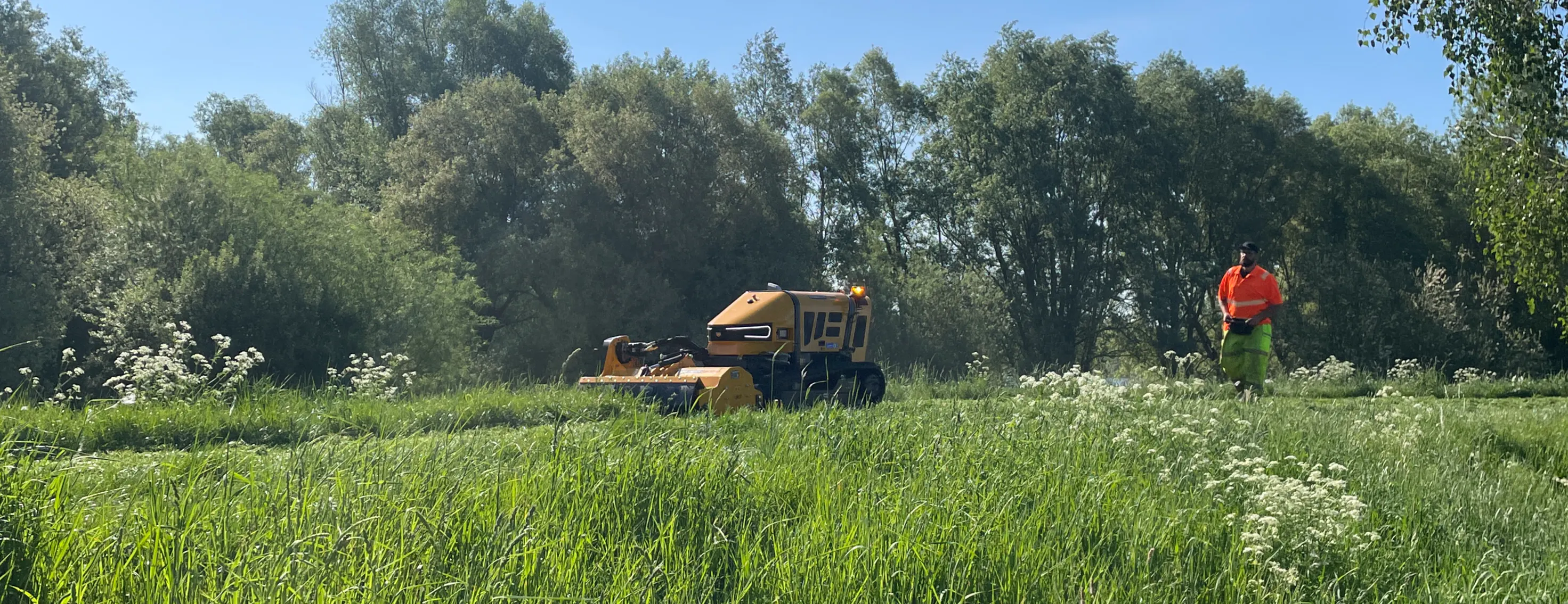
Why do we cut grass?
Grass cutting - reducing flood risk
You may have seen our Environment Agency teams (and contractors on our behalf) out and about cutting grass on the thousands of kilometres of Main River, sea and reservoir banks that serve as flood defences. These banks are man-made and help reduce the risk of flooding to people and property.
Embankments need regular maintenance. The Environment Agency bids for public funding every year to carry out this maintenance and we use our permissive (discretionary) powers to deliver the works. Other ordinary watercourses (dykes/streams) are still important to local flood risk, but are likely owned by the landowner who will be responsible for its maintenance and conveyance.
How do we cut the grass?
Grass cutting will be carried out by using either a mechanical plant fitted with a flail, by hand or by remote controlled mowers where slopes are steep or unsuitable for larger plant.
Why are we cutting grass at this time of year?
It is essential that flood defence embankments (coastal or river) are mown regularly throughout the grass growing season as it is essential they are kept in good condition.
So why do we cut the grass?
Research has shown that the regular close mowing (10-15cm) of grass improves the strength of the root network and erosion resistance of the grass sward. This sward helps protect the earth embankment underneath from external erosion caused by rainfall, wind, currents, wave action and traffic (vehicular, pedestrian and animal).
Regular cutting also prevents broad leafed plants and woody vegetation from getting established. Such vegetation can damage the embankment beneath by root penetration, overturning, encouraging burrowing animals, discouraging adequate grass growth and concentrating flows which then cause scour.
Shorter vegetation helps our teams monitor and inspect our defences, which we do regularly (six monthly, annually or every other year) to identify any signs of damage. Shorter vegetation is also a health and safety measure to help define the edge of the crest when we are cutting our raised embankments.
We are working to create a better place in everything we do. We have a team of biodiversity experts whose role it is to advise and help us adapt our maintenance work to support biodiversity where possible.
What checks do we put in place for nesting birds?
Some of our grass cutting and maintenance does need to be carried out during nesting bird season. Nesting birds are legally protected, and so we apply stringent environmental checks before any work is carried out.
Our staff are diligent and will stop work if they see something of interest to get further advice. If a nesting bird is found, our machine operators will leave a 10 metre perimeter on either side of the nesting area, so as not to disturb the nest.
Who can I contact for more information?
If you would like further information on maintenance, please get in touch using the contact details below:
Post - National Customer Contact Centre PO Box 544 Rotherham S60 1BY United Kingdom
Email - LNenquiries@environment-agency.gov.uk
Telephone - 03708 506 506 (Monday to Friday, 8am-6pm)
Incident Hotline - 0800 80 70 60 - to report flooding, blockages, pollution, unusual changes in flow of water, collapsed or badly damaged defences (24-hour service).
What is river vegetation management?
River vegetation management - reducing flood risk
Environment Agency teams (and contractors on our behalf) manage vegetation and weed growth along 2,210 kilometres of Main River across the Lincolnshire and Northamptonshire area. This regular maintenance aids the passage of water and can reduce flood risk to people and property.
The Environment Agency has permissive or discretionary powers to maintain and improve Main Rivers for the efficient passage of flood flow and the management of water levels. We are not obliged to carry out either maintenance or new works on Main Rivers, but where it provides the greatest reduction to flood risk to protect people, property, and wildlife. We bid for public funding every year to carry out this and other types of maintenance and work alongside riparian landowners and other Local Authorities who also share this responsibility.
Why and how does vegetation, like weed, grow in the rivers?
Aquatic plants are a very valuable part of the aquatic ecosystem. They are a primary food source for aquatic fauna and provide habitat and shelter for a wide diversity of wildlife. They also help protect the banks and bed of the river from erosion and help to modify the velocity of water. However, aquatic plants can become a problem if their growth affects the passage of water in the river or the wildlife in it. At this point, some form of vegetation management may become necessary.
Why do we remove vegetation from rivers?
The Environment Agency removes vegetation in rivers to reduce flood risk. Reducing flood risk isthe primary purpose of maintenance to Main Rivers and what we are funded to do. However, our maintenance budget is limited and we cannot remove weed from every Main River.
We must prioritise rivers which provide the greatest benefit to flood risk. We focus our resources where they are most needed, protecting people, homes and businesses.
Removing weeds from channels helps water move freely, aiding its passage. When high river flows occur, less weed will help ensure the water can move more freely down the river and away from properties.We also do some vegetation management to aid navigation along rivers where we are the Navigation Authority.
How do we cut the weed?
Removing and cutting vegetation in river channels is carried out by a variety of methods such as boats with cutters, long arm excavator machines; rakes and cutting by hand. The type of method used depends on the characteristics of the river and weed growth, and accessibility to the river. Weed boats are the most effective method of cutting in large watercourses. You may be unable to see the weed we are cutting, because it grows from the riverbed itself. These boats and excavators are designed to remove weed under the water before it reaches the surface.
When do we cut vegetation in rivers?
Our programme of maintenance is scheduled to help ensure we are cutting in river channels during the late growing season, so it reduces the chance of vegetation returning before the next cut. Some rivers may have more than one cut a year, dependent on levels of flood risk or to inspect flood risk structures. Timings can change due to a variety of factors such as bank conditions or weather; however, we mainly cut between August and October, so the banks are winter ready. We are working with a variety of other organisations and community groups such as fishing groups to gain mutual benefit, but ultimately our priority is to reduce flood risk.
Why do we leave the cut vegetation on the banks?
River weed is a natural material and does not cause any harm to the environment. Where possible, cut vegetation and weed is placed carefully on the high side of the embankmentswhere it cannot be washed back into the river. This allows any animals trapped in the weed to make their way back to the water, and to ensure that any water vole burrows are protected from being blocked. If we identify an invasive species that could harm the area, we will remove it safely.
We appreciate that when removing material from the river we may also remove litter that was caught up in it. Unfortunately, we do not have the resources and funding to dispose of it somewhere else. We encourage local communities to carry out litter picks along their local river, which could be timed alongside when we carry out a weed cut.
How do we safeguard biodiversity during these works?
We are working to create a better place in everything we do. We have a team of biodiversity experts whose role it is to advise and help us adapt our maintenance work to support biodiversity where possible. In the bird breeding season, the working area is checked for nesting birds prior to works. We closely monitor the levels of dissolved oxygen in the water, especially in warm weather, and stop work if the levels start to fall.
We also support biodiversity by leaving a margin of vegetation habitat on one or both sides of the river. When we cut vegetation in the river, we may also leave a margin along one or both sides of the channel. This encourages river wildlife by creating habitat, and also helps protect the bottom of the river bank from erosion. Leaving a margin depends on the characteristics of the river and the level of benefit it will bring.
Who can I contact for more information?
If you would like further information on maintenance, please get in touch using the contact details below:
Post - National Customer Contact Centre PO Box 544 Rotherham S60 1BY United Kingdom
Email - LNenquiries@environment-agency.gov.uk Telephone - 03708 506 506 (Monday to Friday, 8am-6pm)
Incident Hotline - 0800 80 70 60 - to report flooding, blockages, pollution, unusual changes in flow of water, collapsed or badly damaged defences (24-hour service).
What are asset inspections?
Asset Inspections
What you might see
You may see our Environment Agency teams, or contractors on our behalf, out and about inspecting flood risk management assets on or near Main Rivers in our area. This could involve asset inspectors walking along our embankments, or around flood risk management structures, and recording what they see; asset inspectors entering confined spaces with support of colleagues, to ensure their safety; or even drone operators investigating confined spaces such as culverts.
What are we doing and why?
We have a team of asset inspectors who routinely inspect all our assets to make sure they are at the required condition to manage flood risk. Where we identify assets that have fallen below this condition, we will consider the best options for repair, based on risk. During and after high river levels, we increase our inspections to assess any damage caused by the assets being under pressure.
Who can I contact for more information?
If you would like further information on riparian ownership, please use the contact details below:
Post - National Customer Contact Centre PO Box 544 Rotherham S60 1BY United Kingdom
Email - LNenquiries@environment-agency.gov.uk
Telephone - 03708 506 506 (Monday to Friday, 8am-6pm)
Incident Hotline - 0800 80 70 60 - to report flooding, blockages, pollution, unusual changes in flow of water, collapsed or badly damaged defences (24-hour service).
What is animal exclusion and relocation?
Animal Exclusion and Relocation
What might you see?
In Lincolnshire and Northamptonshire, you may see our Environment Agency teams or contractors on our behalf, out and about undertaking work to control the effects of burrowing animals. This can include rabbits, badgers and foxes which damage our flood and coastal risk management assets. The effects can weaken structures and increase the potential for leaks and failure during a flood.
Some species are protected under legislation, so actions affecting them may need to be licensed and carried out in an agreed way. Our teams in Lincolnshire and Northamptonshire work closely with Natural England early on and continuously throughout the process.
Common burrowing animals
The effects of burrowing animals are likely to be caused by badgers, rabbits, otters, water voles, rats and moles. This list includes the most common cases and those species where individual animals, or groups of animals, living on land or by water, may cause significant damage to our assets when they burrow.
Exclusion and relocation
To protect our embankments, wildlife is excluded from their setts, borrows and housing and relocated to artificially built habitats nearby. Rabbits, rats and moles are species that are not protected by the same legislation, so we are not required to relocate them. Additionally, before carrying out our maintenance work on and in specific areas, sites are surveyed for reptiles, bats and birds. Relocation and or alternate housing is put in place for this wildlife. Additional surveys are carried out throughout the maintenance works to relocate any remaining reptiles, bats or birds.
Who can I contact for more information?
If you have concerns about navigation, please contact your Navigation Authority.
If you would like further information, please use the contact details below:
Post - National Customer Contact Centre PO Box 544 Rotherham S60 1BY United Kingdom
Email - LNenquiries@environment-agency.gov.uk
Telephone - 03708 506 506 (Monday to Friday, 8am-6pm)
Incident Hotline - 0800 80 70 60 - to report flooding, blockages, pollution, unusual changes in flow of water, collapsed or badly damaged defences (24-hour service).
What are Operational and Maintenance checks?
What are Operational and Maintenance checks?
What you might see
You may see our Environment Agency teams, or contractors on our behalf, out and about operating our flood risk management assets to ensure they are functioning correctly.
They could also be clearing any screens that catch debris on Main Rivers.
What we are doing and why
We routinely carry out maintenance and operational checks all year round on watercourses and flood risk management assets. This includes checking that water can move freely through the channel and clearing any blockages, and checking and clearing debris screens.
We also check and operate our structures to ensure they will perform correctly when needed, to protect people from flooding, and we report any issues that will require further investigation and/or work with our partners and landowners.
Who can I contact for more information?
If you would like further information on maintenance, please get in touch using the contact details below:
Post - National Customer Contact Centre PO Box 544 Rotherham S60 1BY United Kingdom
Email - LNenquiries@environment-agency.gov.uk Telephone - 03708 506 506 (Monday to Friday, 8am-6pm)
Incident Hotline - 0800 80 70 60 - to report flooding, blockages, pollution, unusual changes in flow of water, collapsed or badly damaged defences (24-hour service).
Our less frequent maintenance FAQs
Who manages windblown sand?
Windblown sand
Sand blowing off the beach and onto promenades, business frontages and property gardens is a regular annoying occurrence, and something we have seen over many years.
We appreciate that it can be difficult to understand the roles of the different authorities and their remits on sand clearance, and where that leaves you as a resident, landowner or business owner.
Below are some answers to questions frequently asked by communities, and hopefully some clarity on who does what.
Whose responsibility is it to carry out sand clearance from promenades, businesses and private properties?
There is no one responsible authority for sand clearance.
Various authorities and local groups have taken on sand clearance over the years, from East Lindsey District Council through to Parish Councils and community groups. Authorities tend to only clear lengths that are within their ownership.
All authorities sympathise with homeowners and businesses who have issues with sand on their property, but the responsibility to clear sand ultimately falls to the landowner, as with all maintenance and beach care issues.
What sand clearance do the different authorities carry out?
• Environment Agency
The Environment Agency does carry out some minor sand clearance at tidal flood gates and access points to the splash deck service road (promenade), enabling them to perform their duties effectively. The Environment Agency does not have any land ownership along the length of promenade. Their role is to reduce flood risk to people and property, and resources need to be focussed on this.
The Environment Agency has supported local businesses and communities with sand clearance in previous years, as they are sympathetic to the issues it can cause. Unfortunately this becomes more and more difficult to commit to due to the impact on their resources elsewhere. The first priority must be to deliver activities to protect people and property from flooding.
• Lincolnshire County Council
The County Council carries out limited sand clearance on land in its ownership or management, predominantly at Huttoft Car Terrace, on some public rights of way and parts of the England Coast Path.
Whilst every endeavour is made to ensure access along these stretches remains available there will naturally be periods of time when prevailing weather will cause more than usual amounts of sand to accumulate. Resources remain limited in terms of the number of times the authority can attend and clearance must be timed to provide as much benefit and value as possible.
• East Lindsey District Council
East Lindsey District Council removes sand from the top of the sea defences that are located on district council managed areas. These broadly cover Mablethorpe, Sutton on Sea and Skegness beaches. As a priority ELDC focusses resource to ensure access around the central beach areas, businesses, chalets, main access points and ensures that the emergency access points are clear. However, there will be occasions where due to wind direction and the build-up of sand on the beach, when the promenades will be covered by sand.
Why do we have such high levels of sand on the beach?
Since 1994 we have nourished the beaches in Lincolnshire between Mablethorpe and Skegness with sand to provide a wide defence which reduces the impact of wave action and tides, in combination with the existing hard and soft flood defences.
Without beach nourishment, there would be little sand left on the beaches. The sand plays a vital part in protecting the defences. Without this protection, there would be an increased chance of the defence becoming breached during stormy weather. Large areas of land behind the seawall are at or below sea level and such breaches would be devastating for homes, businesses and agriculture. The sandy beaches not only help to protect and preserve the defences but also provide an ideal attraction for tourists visiting the area.
I have sand on my property, what can I do?
It does ultimately fall to the landowner to clear the sand from their property. If you have windblown sand on your property/land, you can return clean sand to the beach.
Contaminated sand (i.e. sand mixed with large quantities of soil) from property’s can be taken to local Household Waste Recycling Centre. A daily limit of up to 120 litres will be accepted per household.
For issues with sand on promenades, or more substantial problems on your private land, we would advise contacting the highway authority to report issues with sand in the first instance. There is an online form to complete to raise issues with Lincolnshire County Council https://fixmystreet.lincolnshire.gov.uk/.
If you would like to discuss an issue with a particular authority we are happy to listen and advise accordingly dependent on the situation. Please find the different contact details below:
Environment Agency General enquiries
National Customer Contact Centre - PO Box 544, Rotherham, S60 1BY
Email - enquiries@environment-agency.gov.uk
Telephone - 03708 506 506 (Monday to Friday, 8am to 6pm)
East Lindsey District Council
Neighbourhood Services on 01507 601111
Email - cleansing.team@e-lindsey.gov.uk
Lincolnshire County Council
Email - countryside_access@lincolnshire.gov.uk
Why do we do tree maintenance?
What you might see
You may see our Environment Agency teams, or contractors on our behalf, out and about maintaining trees around watercourses and flood risk management assets. They could be removing low hanging or loose branches or roots that could obstruct the flow of water.
The Environment Agency bids for public funding every year to carry out this maintenance, and we use our permissive powers to deliver the works on or near
Main River, where it will reduce the risk of flooding. On other watercourses, the landowner will be responsible for maintenance of trees on their land.
What we are doing and why
We carry out tree and bush work over the winter months. This involves cutting back tree branches or bushes that impact on the flow of the water or are likely to fall into the watercourse and cause a blockage, increasing flood risk. We also remove any felled trees from the river where there is cause for concern.
How we are supporting wildlife and the environment
Whilst our priority is to protect people and property from flooding, we also have a duty to protect the environment. Our work only takes place at suitable times during the year to avoid any disruption to nesting birds. Where we have removed branches and tree trunks from the river or banks, we leave them in the nearby area to provide habitat for wildlife. Potential bat roosts are also identified and worked around.
Who can I contact for more information?
If you would like further information on maintenance, please get in touch using the contact details below:
Post - National Customer Contact Centre PO Box 544 Rotherham S60 1BY United Kingdom
Email - LNenquiries@environment-agency.gov.uk
Telephone - 03708 506 506 (Monday to Friday, 8am-6pm)
Incident Hotline - 0800 80 70 60 - to report flooding, blockages, pollution, unusual changes in flow of water, collapsed or badly damaged defences (24-hour service).
What is excessive floating vegetation?
Excessive Floating Vegetation
Each year, carpets of floating vegetation clog up stretches of our waterways. It can look unsightly and causes concern for river activities from fishing to boating navigation. Additionally, it can distress the river’s ecosystem which provides an important habitat for other flora and fauna.
What is excessive floating vegetation?
These kind of “floating weeds” occur naturally, and are commonly known as “pondweeds”, which are native to the UK. They normally occur during spring and summer in response to rising temperatures and longer days, and it is a familiar sight in ponds and rivers across the UK. Growth can be more widespread than expected due to conducive growing conditions and can be made worse due to low rainfall. This causes floating weed to accumulate if it can not be ‘flushed out’ of watercourses as would normally happen.
What does floating weed look like?
Floating vegetation can form a green carpet of varying thicknesses which can spread across and along a river. Depending on the conditions, these green coverings may cover only parts of a river or continue over several kilometers.
Algae, floating Pennywort, and duckweed can look very similar to the naked eye. All can cause issues during hot weather due to their ability to grow and spread quickly but they also have different impacts and risks.
As duckweed is made up of lots of small plants together. When it is disturbed, it will break apart.
Algae, however, will stay together. Algae also has a slimier appearance when compared to duckweed which has tiny, smooth leaves.
Floating pennywort is also a collection of smaller plants with kidney shaped leaves. It is classed an Invasive Non-Native Species and can spread incredibly quickly, up to 20cm a day, blocking light and reducing oxygen in the water for species living there. If you suspect Floating Pennywort in the watercourse, please let us know as soon as possible so we can begin to treat it. This is because floating pennywort is a plant species not native to the UK with specific legislation in place to ensure its responsible management. Find out more about the work being done to tackle Floating Pennywort ‘Wonder Weevil’ released in fight against invasive floating pennywort - GOV.UK (www.gov.uk).
We are aware of another invasive species similar in appearance and impact to pondweed, called Azolla (Azolla filiculoides) that may also be present along some stretches of our rivers. This can be green and may also take on a pinkish tinge.
Does floating weed increase flood risk?
The “pondweed” types of floating vegetation described do not present a flood risk.
Does floating weed reduce the water quality for habitat and / or fish?
Floating weed can impact water quality. We may act where there is a sudden degradation in water quality caused by the presence or decay of floating weed or algal blooms. This can reduce the dissolved oxygen levels which can impact fish habitats and populations. We take a risk-based approach in line with our normal incident response procedures (guided by the Common Incident Classification Scheme), to help us determine if further action is necessary.
Does the presence of floating weed mean the water quality of the river is poor?
The growth of floating vegetation depends on several factors which include excessive nutrients and higher water temperatures. However, the presence of excessive amounts of floating weed does not indicate that water quality has changed or is poor.
For example, in 2021 the River Ancholme (Bishopbridge to Humber) was impacted by long stretches of floating weed. Yet we have past data to show that under the Water Framework Directive (WFD), the water quality indicators of Dissolved Oxygen, Ammonia, pH and Temperature on the Ancholme all met a ‘High’ status. Invertebrate ecology also indicated ‘High’ status. Phosphate was classed as ‘Moderate’ status. These classifications are consistent with the first WFD assessment in 2009, indicating that water quality had remained stable since the late 2000’s.
We are always working with farmers and other businesses across multiple sectors whose activities could impact on our rivers to try and reduce the discharge of any substances that can reduce water quality.
Who can I contact for more information?
If you have concerns about navigation, please contact your Navigation Authority.
If you would like further information, please use the contact details below:
Post - National Customer Contact Centre PO Box 544 Rotherham S60 1BY United Kingdom
Email - LNenquiries@environment-agency.gov.uk
Telephone - 03708 506 506 (Monday to Friday, 8am-6pm)
Incident Hotline - 0800 80 70 60 - to report flooding, blockages, pollution, unusual changes in flow of water, collapsed or badly damaged defences (24-hour service).
What is dredging and desilting?
What is dredging and desilting?
Dredging and desilting are ways of clearing rivers to help water flow more easily. Over time, fine gravel, soil, and other materials wash into rivers from surrounding land and settle on the riverbed. This build-up of silt can slow the flow of water.
Dredging is a big task. It involves removing a wide range of materials and sometimes makes the river channel deeper or wider. Because it’s more complex, dredging happens less often.
Desilting is a smaller, more frequent job. It removes recent deposits of silt to bring the river back to its normal bed level.
Historically in the England, dredging and desilting were done for many reasons such as draining land, powering mills, extracting sand and gravel, improving navigation, and reducing flooding. However, these activities sometimes caused unintended problems, like increasing flood risk downstream.
Does dredging and desilting prevent flooding?
On their own, dredging and desilting are rarely the most effective or sustainable ways to reduce flood risk. In fact, they can sometimes make flooding worse for communities downstream by speeding up the flow of a river shortening the time it takes for water to travel downstream. As a result, floodwaters reach communities more quickly and in larger quantities.
Rivers naturally collect silt again very quickly, sometimes just weeks after dredging. This is especially true for tidal rivers, where every tide brings in more silt. Any extra capacity created by dredging is usually short-lived.
Historic evidence and modelling show dredging can also cause problems like increasing erosion, weakening flood defences and bridges, and harming wildlife habitats.
During major floods, dredging offers very little benefit. The extra depth or width it creates is too small to hold the huge volumes of water, so flooding still occurs. While dredging can lower water levels during normal flows, the effect is minimal during high flows when rivers are already full.
Why doesn’t the Environment Agency do more dredging?
We do dredge and desilt where it makes a real difference. In 2023/24, nationally we spent about £7 million on these activities, alongside £38 million on other river maintenance like clearing weeds and blockages.
Before we dredge, we carefully assess will it reduce flood risk, is it sustainable and cost-effective, and what’s the environmental impact?
If dredging meets these, we do it. If not, we focus on other measures that work better and cause less harm to the environment.
What’s the impact on the environment?
Dredging and desilting can seriously harm river habitats. For example, it can destroy fish spawning grounds, make riverbanks unstable, and it can stir up silt leading to a reduction in oxygen in the water and release harmful chemicals. Additionally, removed silt can be hard to dispose of, especially if it’s contaminated.
We always check for environmental risks before starting work and aim to improve habitats or minimise harm wherever possible.
How else do we reduce flood risk?
Managing flood risk across the whole river catchment is far more effective than relying on dredging alone. Here’s what we do:
• Flood defences: Walls, embankments, and temporary barriers keep water in the river channel.
• Flood storage: We create areas to hold excess water upstream, like parkland, so it doesn’t rush downstream.
• Natural flood management: Planting trees, restoring peatlands, and building leaky dams slow water flow.
• Urban solutions: Working with councils to add ponds and green spaces that soak up rainwater.
What can you do?
Across the country, we work closely with other Risk Management Authorities such as local authorities and Internal Drainage Boards to manage flood risk. However, flooding can’t always be prevented, so it’s important to be prepared.
That’s why we need people to know their risk. We encourage everyone to check online if they are at risk of flooding, sign up for flood warnings, and if they are at risk, know what to do when flooding hits. You can find this information here: https://www.gov.uk/flood
Householders and business owners can also take other action to protect their property, such as installing Property Flood Resilience (PFR) measures found here: https://www.ciria.org/resources/free_publications/cop_for_pfr_resource.aspx
These can include flood doors, airbrick covers, and flood-resistant coatings on walls. These help to either keep water out of properties or allow a quicker return to normality after flooding.
Who can I contact for more information?
If you would like further information on riparian ownership, please use the contact details below:
Post - National Customer Contact Centre PO Box 544 Rotherham S60 1BY United Kingdom
Email - LNenquiries@environment-agency.gov.uk
Telephone - 03708 506 506 (Monday to Friday, 8am-6pm)
Incident Hotline - 0800 80 70 60 - to report flooding, blockages, pollution, unusual changes in flow of water, collapsed or badly damaged defences (24-hour service).