
Air Quality Monitoring
The Environment Agency has a network of two Mobile Monitoring Facilities (MMFs) in the vicinity of Walleys Quarry Landfill. The MMFs monitor ambient air around the site generally, including the presence of methane and hydrogen sulphide (H2S), which are surrogates for odour. We share the monitoring data on a weekly and monthly basis with our partners and the public.
Latest Air Monitoring Data
The table below contains a summary of the raw data collected from our mobile monitoring facilities in the period 13 July - 26 July 2026. The images below shows the number of odour reports the Environment Agency received during the week of 13 July - 26 July 2026.
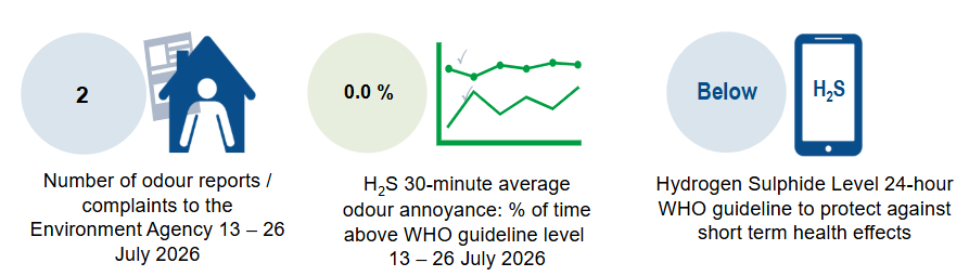
Hydrogen sulphide concentrations above the WHO odour annoyance guideline level were recorded for a very short period (0.9% of the time) at our mobile monitoring facilities (MMFs) in the week commencing 23 March 2026. We have reviewed all circumstances, including activities onsite and meteorological conditions, and have concluded that Walleys Quarry was not the source of the odour.
It is important to note that this data is based on indicative and incomplete raw data. It does not provide the magnitude of H2S detected, but a percentage of time above the WHO odour annoyance guideline level.
The raw data has not been subject to quality assurance checking or calibrations, and should therefore be treated with caution as it will change once these processes have been undertaken. Rectified data which has been subject to quality assurance and calibration is published monthly on the right-hand side of this page.
We share this monitoring data with our partners, UK Health Security Agency (UKHSA), Staffordshire County Council (SCC) and Newcastle-under-Lyme Borough Council (NuLBC). The UKHSA uses the data provided in producing its monthly health risk assessments, which you can find on the right-hand side of the page.
How we carry out air quality monitoring
In March 2021 we deployed mobile MMFs at various locations in response to reports of odour in the vicinity of Walleys Quarry.

Figure 1: Location of the Mobile Monitoring Facilities
A range of factors have to be considered when choosing monitoring locations. We chose the monitoring sites here, in particular, because they were within residential areas where odour reports had been received and there was access to the necessary power supply. We also had regard to prevailing wind direction, the local topography, and the requirement for suitable hard standing. The MMFs monitor ambient air around Walleys Quarry generally, which may include emissions from other local sources.
As it is not possible to measure odour in the way the human nose detects it, we use methane (CH4) and hydrogen sulphide (H2S) as a surrogate or alternative for measuring odour pollution. They are major components of landfill gas.
Where possible, we consider recorded data against the UK Air Quality Strategy (AQS) objectives, or where this is not possible, against other commonly used guidelines such as the World Health Organisation (WHO) air quality guidelines or the health-based guidance values used by the UK Health Security Agency (UKHSA).
We also monitor meteorological conditions, namely wind direction, wind speed, temperature and pressure, at the MMFs.
Table 2: Current monitoring locations
| Mobile Monitoring Facility (MMF) | Bearing of Walleys Quarry from MMF | Angle covered | Distance from landfill site (km) |
| MMF Galingale View | 225° - 320° | 95° | 0.4 |
 Picture 1: MMF situated at Galingale View Pumping StationThe network of MMFs that we currently have in place has proved very effective. The data capture rates have been very high and enable us to build a very detailed picture of the local ambient air quality.
 Picture 2: Annotated photograph of MMF exterior
We have put together a video which explains what an MMF does and what is inside a MMF, which you can view here.
Monitoring reports
Our national Ambient Air Monitoring Team operates the MMFs. It produces monthly Air Quality Reports, monthly Rectified Air Quality Data, and longer term (interim) Air Quality Reports.
The team conducts all its monitoring and data handling using recognised standards and methodologies. Rectified data, which appears in our weekly updates and monthly air quality reports, is data that has been subject to basic quality assurance checking. It may be revised once calibrations are applied to the full data when monitoring is concluded. This is a standard approach taken when conducting highly sensitive ambient air monitoring.
Hydrogen Sulphide levels
It is important to note that there will always be short-term fluctuations in the concentrations of any H2S leaving the site, especially given the low concentrations we are monitoring. The causes can include factors such as the impact of works being carried out on site, and changes in the weather.
Concentrations of landfill gas emissions generally increase overnight, during periods of colder weather, and in still wind conditions with clear skies. By contrast, in warmer weather the gases are naturally more diluted due to higher temperatures and rising air.
Certain weather conditions and the local topography can cause odour to be more noticeable at this landfill site. This is due to something called katabatic flow. You can find our short animation to help explain why here: How weather affects landfill sites.
-
A video to explain what the mobile monitoring facilities are
-
-

